quote

Tune in Earthfiles YouTube Channel LIVE Wednesdays
@ 9:30pm Eastern/6:30pm Pacific — youtube.com/earthfiles

YouTube link
Special Earthfiles YouTube Channel interview
with Earthfiles Reporter and Editor Linda Moulton Howe.

 Chilbolton Observatory – What Does It Do?

 The Chilbolton Observatory is on the edge of Chilbolton village across the Test River from Wherwell, Hampshire, U. K. south of Andover. Crop formations historically first appeared in Hampshire and have continued to evolve repeatedly at places such as the Chilbolton Observatory, Goodworth Clatford, Middle Wallop, and Danebury Fort.
The Chilbolton Observatory is on the edge of Chilbolton village across the Test River from Wherwell, Hampshire, U. K. south of Andover. Crop formations historically first appeared in Hampshire and have continued to evolve repeatedly at places such as the Chilbolton Observatory, Goodworth Clatford, Middle Wallop, and Danebury Fort.
Chilbolton Observatory, a British government-owned facility, was originally constructed in 1965 to study radio wave propagations from space and satellites. The Observatory is off limits from the public. The wheat field that runs along its boundary, as shown in above photograph, is privately owned and operated by the Leckford Estate. Aerial photograph © 2001 by Lucy Pringle.

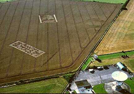
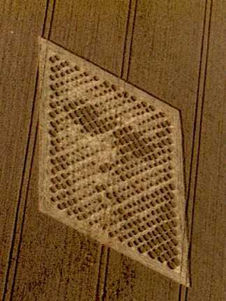
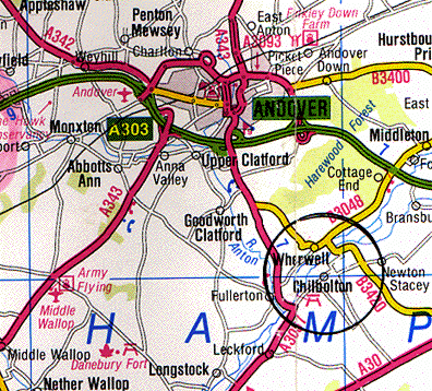
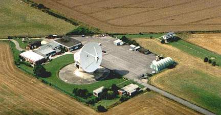
August 30, 2001 Chilbolton, Hampshire, England - On Tuesday, August 28, The Daily Mail finally published a news story with photographs by researcher and author, Lucy Pringle, about the controversial "face" and "binary code" in the wheat field next to the Chilbolton Observatory south of Andover, Hampshire. Chilbolton Observatory is a government-owned installation that was constructed in 1965 to study radio wave propagations from space and satellites and is owned and operated by the Rutherford-Appleton Laboratory under the U. K. Office of Science and Technology. Cereal crop fields that run along the barbed wire boundary of the Observatory are owned and operated by various farmers. The wheat in which the formations appeared is owned by the local Leckford Estate and by Wednesday, August 29, the Estate had cut down the "face" and "binary code" in its normal wheat harvest.


Click here to subscribe and get instant access to read this report.

Click here to check your existing subscription status.

Existing members, login below:

Part 1 – Ground Details of Chilbolton “Face”

The "binary code" on the left and "face" to the right in the wheat field near Chilbolton Observatory near Wherwell, Hampshire, U. K. were first seen on different dates, according to a Chilbolton Observatory employee. The "face" near top center was reported on Tuesday, August 14, 2001. The "binary code" to the left was reported on Monday, August 20, 2001. Aerial photograph © 2001 by Steve Alexander.
Aerial photograph of "face" on August 20, 2001 © by Lucy Pringle.

August 29, 2001 Wherwell, Hampshire, England - Field researcher, Charles Mallett, from Devizes, Wiltshire, England traveled to Wherwell Hampshire with his wife, artist and fellow field researcher Frances soon after the "code" formation was reported to have appeared near the "face" in the wheat field next to Chilbolton Observatory on August 20. The following is a photo essay by Charles of the unique "pixel" lay of the plants inside the "face."


Click here to subscribe and get instant access to read this report.

Click here to check your existing subscription status.

Existing members, login below:

Are Crop Formations at Chilbolton Observatory A Response to 1974 Earth Transmission?

The "binary code" on the left and "face" to the right in the wheat field near Chilbolton Observatory near Wherwell, Hampshire, U. K. were first seen on different dates, according to a Chilbolton Observatory employee. The "face" near top center was reported on Tuesday, August 14, 2001. The "binary code" to the left was reported on Monday, August 20, 2001. Aerial photograph © 2001 by Steve Alexander.

August 25, 2001  Chilbolton, Hampshire, England - For the past few years, crop formations have appeared in the wheat field near the Chilbolton Observatory in Chilbolton village, south of Andover, Hampshire. The one from August 2000 now seems linked to the August 2001 formations. Last year's was one of England's largest 2000 formations in terms of square footage and appeared next to the Chilbolton government-owned land upon which the radio telescope complex was built in 1965. The facility is sectioned off from the public and is surrounded by a high barbed wire fence. The estimated measurements of the code formation is 200 feet long and 85 feet wide; the estimated face measurements are approximately 160 feet wide and 180 feet long. Both are framed by wheat laid down in almost identical fashion, according to field researcher, Charles Mallett, from Roundway, Wiltshire.


Click here to subscribe and get instant access to read this report.

Click here to check your existing subscription status.

Existing members, login below:

Part 2 – Unusual Montana Mutilation of Live Bull

Seven mutilations reported in Great Falls, Montana region from Babb in northwest corner down to Dupuyer, Fort Shaw, Cascade and Belt between June 12 and August 15, 2001.

August 24, 2001  Depuyer, Montana - The first mutilated cow in Montana officially reported to law enforcement this summer was discovered on June 12 on the Don Reishus ranch in Depuyer between Conrad and Great Falls. Don Reishus, Sr., is in his seventies now and could not believe he was seeing another jaw stripped to the bone, eye removed, teat removed and rectum cored out - all without blood like others he had seen in the 1970s on his same Montana ranch.


Click here to subscribe and get instant access to read this report.

Click here to check your existing subscription status.

Existing members, login below:

Milk Hill 2001 – 409 Circles, Most For Any Crop Formation So Far

409-circle, 787-foot diameter formation discovered Sunday, August 12, 2001, after a night of rain. This wheat field is on the highest plateau of Milk Hill and the highest point in the county of Wiltshire, England. The field is not visible from any road and to get there, people must walk about fifteen minutes from the nearest place to park a car. Photograph © 2001 by Lucy Pringle.

August 22, 2001  Alton Barnes, England - Author and researcher, Lucy Pringle, has been flying over crop formations to take aerial photographs and to investigate the plants and soils of English crop formations since the mysterious patterns began evolving from simple circles and rings in 1989. She has been in hundreds. But this formation that was discovered in Ron Read's wheat field on a high plateau of Milk Hill, Wiltshire on Sunday, August 12, overwhelmed her. After measurements were made, there were 409 circles of varying sizes divided into six curved arms stretching 240 meters (787 feet) from one side to the other. The largest central circle was 72 feet in diameter and the smallest little circles that dotted along the large arms were no more than 40 inches in diameter.


Click here to subscribe and get instant access to read this report.

Click here to check your existing subscription status.

Existing members, login below:

Milk Hill 2001 – 409 Circles, Most For Any Crop Formation So Far

409-circle, 787-foot diameter formation discovered Sunday, August 12 after a night of rain. This wheat field is on the highest plateau of Milk Hill and the highest point in the county of Wiltshire, England. The field is not visible from any road and to get there, people must walk about fifteen minutes from the nearest place to park a car. Photograph © 2001 by Lucy Pringle.

August 22, 2001  Alton Barnes, England - Author and researcher, Lucy Pringle, has been flying over crop formations to take aerial photographs and to investigate the plants and soils of English crop formations since the mysterious patterns began evolving from simple circles and rings in 1989. She has been in hundreds. But this formation that was discovered in Ron Read's wheat field on a high plateau of Milk Hill, Wiltshire on Sunday, August 12, overwhelmed her. After measurements were made, there were 409 circles of varying sizes divided into six curved arms stretching 240 meters (787 feet) from one side to the other. The largest central circle was 72 feet in diameter and the smallest little circles that dotted along the large arms were no more than 40 inches in diameter.


Click here to subscribe and get instant access to read this report.

Click here to check your existing subscription status.

Existing members, login below:

Milk Hill 2001 – 409 Circles, Most For Any Crop Formation So Far

 409-circle, 787-foot diameter formation discovered Sunday, August 12 after a night of rain. This wheat field is on the highest plateau of Milk Hill and the highest point in the county of Wiltshire, England. The field is not visible from any road and to get there, people must walk about fifteen minutes from the nearest place to park a car. Photograph © 2001 by Lucy Pringle.
409-circle, 787-foot diameter formation discovered Sunday, August 12 after a night of rain. This wheat field is on the highest plateau of Milk Hill and the highest point in the county of Wiltshire, England. The field is not visible from any road and to get there, people must walk about fifteen minutes from the nearest place to park a car. Photograph © 2001 by Lucy Pringle.

August 22, 2001 Alton Barnes, England - Author and researcher, Lucy Pringle, has been flying over crop formations to take aerial photographs and to investigate the plants and soils of English crop formations since the mysterious patterns began evolving from simple circles and rings in 1989. She has been in hundreds. But this formation that was discovered in Ron Read's wheat field on a high plateau of Milk Hill, Wiltshire on Sunday, August 12, overwhelmed her. After measurements were made, there were 409 circles of varying sizes divided into six curved arms stretching 240 meters (787 feet) from one side to the other. The largest central circle was 72 feet in diameter and the smallest little circles that dotted along the large arms were no more than 40 inches in diameter.


Click here to subscribe and get instant access to read this report.

Click here to check your existing subscription status.

Existing members, login below:

Part 1 – Unusual Cattle Deaths in Montana


August 18, 2001 Conrad, Montana - Twenty-six years ago in the summer of 1975, there were so many cattle mutilations in Montana, Wyoming, Colorado, New Mexico and other parts of the United States and Canada that sheriffs reported some carcasses were still warm to touch with bloodless, "cookie cutter" cuts and no tracks or other evidence. The mutilations had first made national news in the fall of 1974 and continued without letup in many parts of North America and other countries such as Australia, South America, Central America, Mexico, the Canary Islands off the coast of Africa and parts of Europe.


Click here to subscribe and get instant access to read this report.

Click here to check your existing subscription status.

Existing members, login below:

Unusual Cat Deaths in Navarre, Florida and Austin, Texas

Pattie and John Goodfleisch hold their surviving white female cat, Kitty, after they found their other black male cat, Maximum, cut in half on Saturday, June 30, 2001. Photograph © 2001 by Daily News, Milton, Florida.

August 12, 2001 Navarre, Florida and Austin, Texas ­ Since the 1970s, there have been waves of cat mutilations in Canada, the United Kingdom and the United States. In the summer of 2001, more mutilated cats are being found.


Click here to subscribe and get instant access to read this report.

Click here to check your existing subscription status.

Existing members, login below:

Thousands of Corn Leaves Rain on Wichita, Kansas

Thousands of Corn Leaves Rain on Wichita, Kansas
Corn leaves that fell out of the cloudless, blue sky onto Paul Corn's yard in the eastern edge of Wichita, Kansas on Friday, August 3, 2001. Photograph © 2001 by Bryan Corn.

August 11, 2001  Wichita, Kansas - Sales executive Paul Corn was celebrating his nephew's pending marriage with a backyard pool party around 4:30 p.m. on Friday, August 3. The nephew's fiancee was floating on her back in the water when she called out, "Look. There's something spinning down out of the sky." Everyone watched in amazement as first one pale object and then another slowly spiraled down to the yard. Warm to touch, the fragile objects were corn leaves. The group then realized that thousands of leaves were floating in an oval pattern about a thousand feet up in the cloudless, blue sky.


Click here to subscribe and get instant access to read this report.

Click here to check your existing subscription status.

Existing members, login below: