quote

Tune in Earthfiles YouTube Channel LIVE Wednesdays
@ 9:30pm Eastern/6:30pm Pacific — youtube.com/earthfiles

YouTube link
Special Earthfiles YouTube Channel interview
with Earthfiles Reporter and Editor Linda Moulton Howe.

Part 1 – U. S. Nuclear Power Plants On Heightened Alert After Nuclear Regulatory Commission Warning


103 nuclear power plants in the United States above supply about twenty percent of the natin's electricity. Some states such as Kansas have only one reactor. Others such as Pennsylvania have nine reactors, including Three Mile Island which is near the Harrisburg International Airport. Graphic © 2001 by the Nuclear Regulatory Commission.

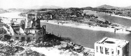
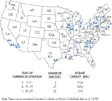
May 25, 2002  Washington, D. C. - This Memorial Day weekend, the U. S. government has announced several terrorist threat warnings. The latest came from the Nuclear Regulatory Commission placing all 103 nuclear power plants throughout the country on a heightened state of alert. This weekend the FBI also warned of possible underwater terrorist attacks by scuba divers that could target nuclear power plants as well. Recently intelligence sources warned that on the Fourth of July, Pennsylvania's Three Mile Island (TMI) could be the target of an Al Qaeda attack. In fact, there is concern that spent radioactive fuel could be stolen to produce a dirty bomb to be set off at nuclear power plants.


Click here to subscribe and get instant access to read this report.

Click here to check your existing subscription status.

Existing members, login below:

Part 2 – “Dirty Bombs” and “Suitcase Nukes”

Hiroshima, after the atomic bomb in Japan, 1945. Photograph and information below from http://mothra.rerf.or.jp/ENG/A-bomb/History/Damages.html
  • Nuclear material was Uranium 235.
  • Energy released was equivalent to 12.5 kilotons of TNT dynamite.
  • Maximum temperature at burst point was several million degrees centigrade.
  • A fireball of 30 meters diameter formed in 0.1 millisecond, with a temperature of 300,000 degrees centigrade and expanded to its maximum size in one second.
  • The top of the atomic cloud reached an altitude of 17,000 meters.
  • Radioactive debris was deposited by "black rain" that fell heavily for an hour over a wide area.
  • Maximum wind pressure of the blast: 35 tons per square meter.
  • Maximum wind velocity: 440 meters per second.
  • Wooden houses within 2.3 kilometers of ground zero collapsed.
  • Concrete buildings near ground zero hit by the blast from above had ceilings crushed and windows and doors blown off.
  • Many people were trapped under fallen structures and burned to death.
  • People exposed within 500 meters of ground zero were killed by the radiation.
  • People exposed at distances of 3 to 5 kilometers later showed radiation symptoms, including radiation-induced cancers.
  • More than 100,000 people died in the atomic explosions at Hiroshima and Nagasaki.

May 25, 2002  Washington, D. C. - The terms "suitcase nukes" and "dirty bombs" do not refer to the same radioactive weapon. A suitcase nuke in the 21st Century is about the size of the atom bomb the United States dropped on Hiroshima and Nagasaki in 1945 that ended World War II. Bomb making technology advanced so much during the Cold War with the Soviet Union that scientists were making similar bombs as small as suitcases, hence the name. Building atomic bombs, small or large, is not easy and the only country thought to have such weapons is Russia. But no one knows for certain where suitcase nukes might be or if any have been sold to countries such as Iran or Iraq.


Click here to subscribe and get instant access to read this report.

Click here to check your existing subscription status.

Existing members, login below:

Third 2002 Crop Formation in Germany Near Giant’s Stone

All three of Germany's 2002 crop formations since April 26 have been in the Kassel region, long famous as the "hot spot" for German crop patterns.

May 23, 2002  Kassel, Germany - The www.invisiblecircle.de researchers in Germany report a third crop formation near Kassel, discovered on May 20, 2002 by Dirk Moeller. The two part formation was in young barley near a geographic site known as the "riesenstein," or giant's stone near the village of Zueschen. All three 2002 Germany formations have been near Kassel; the first at Fritzlar southeast of Kassel found April 26 and the second around the same date north of Kassel. See 05/04/02 Earthfiles.


Click here to subscribe and get instant access to read this report.

Click here to check your existing subscription status.

Existing members, login below:

A Bull Mutilation in Christmas Valley, Oregon

Dozens of animal mutilations and strange unidentified aerial lights have been reported   over several decades in Oregon's Sand Springs region and south into Christmas Valley.
Dozens of animal mutilations and strange unidentified aerial lights have been reported over several decades in Oregon's Sand Springs region and south into Christmas Valley.

May 18, 2002  Fort Rock, Oregon - There is a new report from the Lake County, Oregon Sheriff's Office this month of a bull mutilation in the Christmas Valley of Oregon southeast of Bend. It seems to be a continuation of animal mutilations and very strange aerial lights near the Sand Springs region over the past several decades. One rancher there in 1980 even described seeing cattle drawn up into glowing discs in the sky and dropped back down to the ground, dead and mutilated, the weight of their bodies making craters in the dusty soil. Oregon resident, Dwain Wright, talked with that Sand Springs rancher and described the incident for me when I was producing my documentary Strange Harvests 1993 and my book Glimpses of Other Realities, Vol. II: High Strangeness (see Earthfiles Shop). Here is a brief excerpt from that interview:


Click here to subscribe and get instant access to read this report.

Click here to check your existing subscription status.

Existing members, login below:

More Orange Triangular Aircraft Over Red Deer, Alberta, Canada

Red Deer and Lacombe are about 100 miles south of Edmonton, Alberta,   a larger city which has also had several crop formations in its fields since the late 1990s.
Red Deer and Lacombe are about 100 miles south of Edmonton, Alberta, a larger city which has also had several crop formations in its fields since the late 1990s.

May 9, 2002 Red Deer, Alberta, Canada - Since the first week of September 2001, six nurse's aides at the Lacombe Nursing Home near Red Deer, Alberta, Canada have witnessed several flights of unidentified orange glowing triangular craft during their night shift breaks. For background, please see previous 09/22/01 and 10/27/01 Earthfiles reports that contain drawings of earlier sightings. This morning, I received another phone call from nurse's aide, Penny Pickett, about two more sightings.


Click here to subscribe and get instant access to read this report.

Click here to check your existing subscription status.

Existing members, login below:

“Putnam (sic) Paralellogram” Is Fiction

May 8, 2002 Iowa City, Iowa - I received several e-mail requests to do an investigation of a topic forwarded around in cyberspace the past few weeks in an article entitled "The Putnam (sic) Paralellogram: Iowa's Answer to the Bermuda Triangle?" submitted by Dr. Leonid Rosenweitz. The website listed with the internet article is http://www.yawp.com/3rd-i/current/pp/putnam.html. That website belongs to a loose group of people scattered between Iowa City and Charlottesville, Virginia who like to write fiction and pass it off as non-fiction.


Click here to subscribe and get instant access to read this report.

Click here to check your existing subscription status.

Existing members, login below:

Two Crop Formations Near Kassel, Germany

Fritzlar, a rural community south of Kassel, was the location of the first 2002 formation in Germany discovered by the farmer on April 26. The second formation north of Kassel in an area kept secret at the farmer's request was discovered on May 1, but thought to have been formed earlier, most likely at the same time as the first formation.

May 4, 2002  Saarbruecken, Germany - Crop formation investigator, surveyor and author, Andreas Mueller, reported to me today that two formations have been discovered south and north of Kassel, Germany in oil seed rape so young it had only begun to open its bright yellow flowers. Both formations are thought to have been created the same night on Thursday, April 25. The first near Fritzlar south of Kassel was found by the farmer on Friday, April 26. The second was found May 1 north of Kassel, but the condition of the crop indicated the plants had gone down earlier. In previous years, Kassel has had two formations arrive at the same time and, like Avebury in England, is the geographic focus of the crop phenomenon in Germany. See More Information at the bottom of this report and my Earthfiles reports beginning 05/19/01 about last year's prolific season in Germany.


Click here to subscribe and get instant access to read this report.

Click here to check your existing subscription status.

Existing members, login below:

Canadian Satellite Hunter Tracks Classified U. S. Navy Satellites

Canadian satellite hunter, Ted Molczan, says this analog video frame shows the U. S. Navy's NOSS 2-1 trio of satellites launched in June 1990. Video was taken of three star-like points of light which moved slowly northeast to southwest from the Auriga constellation towards the Leo constellation where they stopped after traveling for three minutes. Estimated time was 11:02 to 11:05 p.m.Central Daylight Time on Sunday, April 14, 2002. Location was the Piney River valley overlook ten miles north of Dover in the Ozark National Forest of northwestern Arkansas. Video © 2002 by Don Kreinbrink.

May 2, 2002  Toronto, Ontario, Canada - Last week on Coast to Coast AM radio, I reported about the enormous triangle of what looked like stars moving slowly through the starry sky above eight of us at the Piney River valley look out north of Dover, Arkansas on April 14. I also interviewed a NASA Goddard scientist about cluster satellites that travel in fours to see if that could explain what we all saw near Dover, but he checked orbital logs and said none of those cluster satellites were on the night side of earth on April 14. (See: Real X-Files 04/22/02 and 04/27/02.)


Click here to subscribe and get instant access to read this report.

Click here to check your existing subscription status.

Existing members, login below:

Aerial Triangles of High Strangeness

May 2, 2002  Philadelphia, Pennsylvania -  After my Earthfiles and Coast radio reports (See: Real X-Files 04/22/02 and 04/27/02 and Science 05/02/02) about a large and slow moving triangle of star-like objects above Dover, Arkansas on April 14, I received hundreds of e-mails about other people's sightings of baffling aerial triangles. Since satellites are characterized by steady forward motion and are not capable of abrupt turns or circling on themselves, I offer the following excerpts from several interviews about triangle sightings of high strangeness which cannot be explained by known human satellites.


Click here to subscribe and get instant access to read this report.

Click here to check your existing subscription status.

Existing members, login below: