New Hampshire’s “Mystery Stone”

“No one to our knowledge has seen anything quite like this.”

– Wesley Balla, New Hampshire Historical Society

July 29, 2006   Concord, New Hampshire –  One hundred and thirty-two years ago in 1872, workmen were digging post holes in the town of Meredith, New Hampshire. One of the workers hit something solid like a stone and lifted out glob of clay. When the dirt was cleaned off, the workers were surprised to see a brown-colored stone about four inches high and two and a half inches wide shaped exactly like a goose egg. All around the egg were carvings. The owner and manager of the post hole project was Seneca Ladd. He was interested in geology and historic relics, so he claimed the “mystery stone” for his private collection.

The dense stone was later identified to be fairly dense quartzite. Today, the stone is housed in the New Hampshire Historical Society in Concord. The Director of Collections and Exhibitions there since 2003 is Wesley G. Balla, M. A. I talked with him this week about the mystery stone and asked him to describe the symbols carved in it.


Interview:

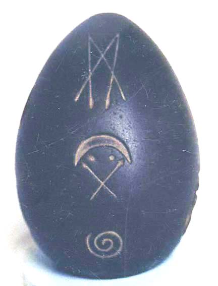
Wesley G. Balla, M. A.,  Director of Collections & Exhibitions, New Hampshire Historical Society, Concord, New Hampshire: “All the way around the sides and the bottom, there are a series of images, symbols, pictographs that have been carved or cut on to the stone. The pictographs include a human face, a teepee, and circle on one side.

Brownish, dense quartzite stone the shape and size of a goose egg about four inches high and 2.5 inches wide. Originally found in the ground by post hole digger in Meredith, New Hampshire, in 1872. Its origin and age are still a mystery. Photographs courtesy New Hampshire Historical Society.

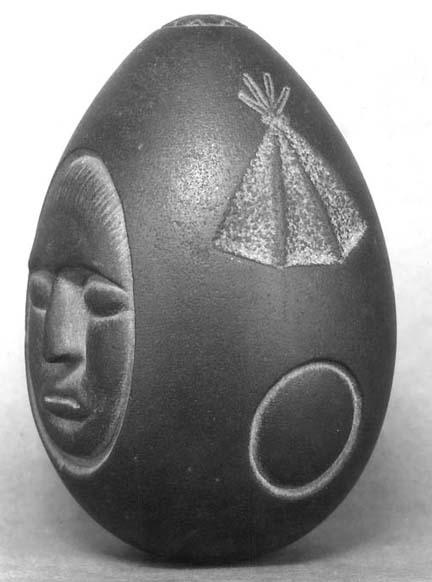
In another section of the mystery stone are arrows or spears, a crescent over crossed spears, and a spiral.

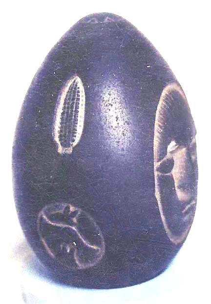
In another section, is an ear of corn over a circle that has a number of other figures inside of it, which are hard to make out. They are sort of curved and angled figures.

On the very bottom drawn around one of the boring holes is a multi-sided geometric figure. It is very precise and even in the way it’s drawn, angles. It’s similar to a star, but it’s really a square superimposed on another square, so there are 8 straighter sides than you would have in the depiction of a star symbol.


Small Machine-Bored Holes At Top and Bottom of Mystery Stone

COULD YOU EXPLAIN THE BORE HOLES AND AT THE TOP AND BOTTOM? HOW WERE THEY MADE AND WHAT WAS THE PURPOSE?

Again, it’s a mystery. We don’t know why they were made or when. We know how they were made, probably by a metal drill. We’ve had an analysis done which suggests that the top hope is about an eighth of an inch in diameter. The bottom hole is 3/8ths inch in diameter. One is larger than the other. There are abrasions or scratches on the inside of each hole that suggest they were made by metal. When? and who? remains a mystery.

AN EIGHTH OF AN INCH FOR ONE OF THOSE HOLES MEANS IT COULD NOT HAVE BEEN MOUNTED ON ANYTHING THAT WAS THICK. IT HAD TO BE MOUNTED ON SOMETHING VERY THIN.

Yes. We assume it was mounted somehow, but there is no real context for any of this. No one to our knowledge has seen anything quite like this. The scratches found in the analysis inside the holes suggests that the egg-shaped stone was probably made in recent history, that it’s not a prehistoric piece because Native Americans did not have the technology to drill with metal.

DID ANYONE EVER TRY TO DATE THE LAYER IN THE GROUND FROM WHICH THE STONE WAS TAKEN?

No, that is one of the things that is conspicuously absent. It was just viewed as something that was pulled up out of the ground. No one said what level or if there was anything else at that level. It was just, ‘We found this when we were digging post holes.’ That’s been the story since 1927 when it was given to the Historical Society. We don’t even know precisely which spot in Meredith it was dug up. If you don’t have a very precise site, it’s very hard to date.

IS THERE ANYTHING IN MEREDITH LIKE AN ANCIENT EARTH MOUND OR STONE CIRCLES OR SOME VERY OLD GROUND MARKING SIMILAR TO THE OHIO EARTH MOUNDS?

Not that I’m aware.

HAVE YOU HAD EXPERTS IN VARIOUS KINDS OF PICTOGRAMS AND RUNE LANGUAGES TO SEE IF THE EGG-SHAPED STONE SYMBOLS COMPARE TO ANY OTHER LANGUAGE OR SYMBOLS?

No, we don’t know anything about the pictographs.”


More Information:

For further information about archaeological mysteries, please see reports below in the
Earthfiles Archives:

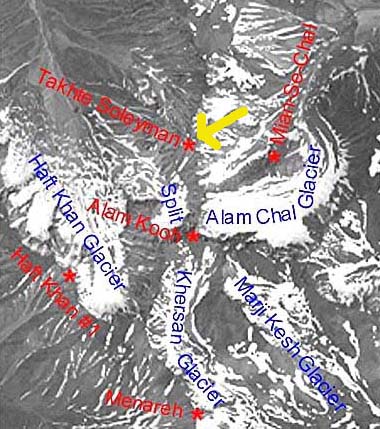
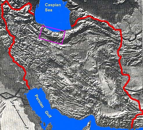
  • 07/07/2006 — Noah’s Ark Atop Takht-e-Soleiman Peak in Iran?
  • 03/26/2006 — “Anomaly” On Mt. Ararat’s Western Plateau?
  • 12/09/2005 — Mystery of “Footprints” in 1.3 Million-Year-Old Mexico Volcanic Rock
  • 05/26/2005 — Part 2 – Corguinho, Brazil: Plasma Balls Which Enter Humans
  • 12/28/2002 — Part 3 – Tall, Red-Haired, Non-Human Beings
  • 11/14/2002 — What Happened 12,000 Years Ago That Killed So Many Animals?
  • 11/02/2002 — Update on 6,500-Year-Old Astronomical Stone Circle and Megaliths in Nabta, Egypt
  • 10/22/2002 — 63 A.D. Inscription Refers to “Jesus” – An Archaeological First
  • 07/13/2002 — More Crop Formations in Holland and Germany
  • 02/16/2002 — Sunken City Off India Coast – 7500 B. C.?
  • 12/28/2001 — Images from Cuban Deep Water Megalithic Site
  • 12/08/2001 — 70,000-Year-Old “Modern Humans” Lived in Blombos Cave, South Africa
  • 11/19/2001 — Update on Underwater Megalithic Structures near Western Cuba
  • 10/05/2001 — Large Prehistoric Underground Circle Found in Chillicothe, Ohio
  • 06/13/2001 — Update on Mysterious Deep Water Sonar Images Off Western Cuba
  • 05/18/2001 — Underwater City Reported Off Western Cuba
  • 05/05/2001 — Archaeologists Find Central Asia Civilization As Old As Sumeria
  • 09/17/2000 — Evidence of 7000 Year Old Flood and Human Habitation Discovered Beneath Black Sea
  • 05/28/2000 — Hamoukar, Syria – A City Older Than 6000 Years?
  • 05/16/1999 — Edgar Evans Cayce About His Father and Atlantis

San Andreas Fault So Stressed, Next Quake Could Be Magnitude 8

“What’s the probability that we’re going to have a large earthquake, magnitude 6, 7 or 8, on the southern part of the San Andreas Fault? There is about a 70% likelihood of a large earthquake within the next 30 years.”

– Seismologist Debi Kilb, Ph.D.

Blue triangles indicate 2006 small quake activity along San Jacinto Fault, Elsinoro Fault, and Rose Canyon Fault, while the San Andreas Fault near the Salton Sea is building more and more energy in a "locked up" mode, moving only 1 inch per year. Map source: USGS.
Blue triangles indicate 2006 small quake activity along San Jacinto Fault, Elsinoro Fault, and Rose Canyon Fault, while the San Andreas Fault near the Salton Sea is building more and more energy in a “locked up” mode, moving only 1 inch per year. Map source: USGS.

July 27, 2006  La Jolla, California –   Last month, the June 22, 2006, issue of the science journal Nature, published recent detailed research of the San Andreas and San Jacinto faults in Southern California. The data shows the San Andreas so stressed that its next quake release of energy could be a magnitude 8 on the Richter scale. The San Andreas Fault is considered the main boundary between the Pacific and North American tectonic plates that are slowly moving past each other. Some day in the far distant future, those moving plates might even break off sections of the Pacific coast into the ocean. The tension between those moving plates is what makes California “earthquake country.”Click for report.

1940s USAF Flight Surgeon’s Account of E. T. Autopsy

See: 11/19/03 Earthfiles   "1954 War Department Training Manual: Extraterrestrial Entities and Technology, Recovery and Disposal - Reasons Manual Is Authentic"  with Robert Wood, Ph.D. This Majestic-12 training manual's 32 pages of text and drawings first appeared on 35mm black and white negative film in a package postmarked March 7, 1994, from LaCrosse, Wisconsin, and addressed to Don Berliner at the Fund for UFO Research in Maryland. Bob Wood, Ph.D., aerospace engineer at McDonnell-Douglas, took on the work to print the negatives for analysis.


July 27, 2006   Central Ohio -  On April 24, 2006, I received an email from a Central Ohio businessman named Ronald SeCoy. He is 59-years-old, has a Bachelor's degree in Clinical Psychology from Ohio University, but has worked in a variety of businesses ranging from restaurants to retail since graduating. He is a family man with three children and considers himself a devout Christian. He has asked that his home city and company's name be withheld for protection. His first email stated:


Click here to subscribe and get instant access to read this report.

Click here to check your existing subscription status.

Existing members, login below:

Giant Hydrocarbon Lakes Found On Saturn Moon, Titan

"Dark patches, which resemble terrestrial lakes, seem to be sprinkled all over the high latitudes surrounding Titan's north pole ... very strong evidence for hydrocarbon lakes."

- NASA and JPL Cassini-Huygens Mission

Two radar images acquired by the Cassini spacecraft radar instrument in synthetic aperture mode on July 21, 2006, near the Titan moon's north pole. The next Titan Flyby will be at 1,000 kilometers (621 miles) on September 7, 2006. Radar images courtesy NASA and JPL.

July 25, 2006 Pasadena, California - NASA and JPL report: "The Cassini spacecraft, using its radar system, has discovered very strong evidence for hydrocarbon lakes on Titan. Dark patches, which resemble terrestrial lakes, seem to be sprinkled all over the high latitudes surrounding Titan's north pole.


Click here to subscribe and get instant access to read this report.

Click here to check your existing subscription status.

Existing members, login below:

U. K. Breaking Heat Records and 17 Crop Patterns Reported Between July 4-20

“A streak of light, like a honey-coloured comet tail, flashed past me at eye level no more than six feet from my head.”

  – William Betts, U. K. Crop Circle Researcher

UPDATED with mysterious light photos July 24, 2006  Petersfield, Hampshire, England  –  It is so hot in southern England right now that the London Zoo is feeding blood-flavored ice blocks to the lions to help keep them cooler. The hottest day ever recorded in a British summer was on July 19th.  London’s Underground subway system has no air conditioning and temperatures have reportedly reached 117 degrees Fahrenheit, while road surfaces south of London have been melting.Click for report.

2006 – Hottest Year So Far in U. S. History

“The average temperature for the continental United States from January through June 2006 was the warmest first half of any year since records began in 1895.”

– NOAA

July 17, 2006, temperature map for mainland United States.

July 18, 2006  Asheville, North Carolina   –  The following is the National Oceanic and Atmosphere Agency’s summary of America’s “record warm first half of year, widespread drought and northeast record rainfall.”

NOAA report on July 14, 2006:  “The average temperature for the continental United States from January through June 2006 was the warmest first half of any year since records began in 1895, according to scientists at the NOAA National Climatic Data Center in Asheville, N.C. Last month was the second warmest June on record and nationally averaged precipitation was below average. The continuation of below normal precipitation in certain regions and much warmer-than-average temperatures expanded moderate-to-extreme drought conditions in the contiguous U.S. However, much of the Northeast experienced severe flooding and record rainfall during the last week of June. The global surface temperature was second warmest on record for June.

U.S. Temperature Highlights

The average January-June temperature for the contiguous United States (based on preliminary data) was 51.8 degrees F (11.0 degrees C), or 3.4 degrees F (1.8 degrees C) above the 20th century (1901-2000) average. Five states (Texas, Oklahoma, Kansas, Nebraska and Missouri) experienced record warmth for the period. No state was near or cooler than average.

The nation observed the second warmest June on record this year. In the West, 11 states were much warmer than average. Only five states (Kentucky, Ohio, Pennsylvania, West Virginia and South Carolina) were cooler than normal for the month.

The June statewide average temperature for Alaska was near average, and January-June was 0.55 degrees F (0.30 degrees C) cooler than the 1971-2000 average.

U.S. Precipitation Highlights

The average precipitation for June 2006 across the continental U.S. was 0.3 in. (8 mm) below the 20th century average.

Record rainfall in parts of the Northeast during May and June contributed to the wetter-than-normal first half of the year for that region. Heavy precipitation along the East Coast from June 22-28 resulted in widespread flooding. For example, Washington’s Reagan National Airport reported 11.37 inches (289 mm) during that time and a record June total of 14.02 inches (356 mm). More than 10 inches (254 mm) of rain fell in Federalsburg on Maryland’s Eastern Shore in a 24-hour period.

In June, 45 percent of the contiguous U.S. was in moderate-to-extreme drought (based on the Palmer Drought Index), an increase of 6 percent from May, while 27 percent was in severe-extreme drought (up from 20 percent in May). Additionally, from January through June, warm, dry conditions spawned more than 50,000 wildfires, burning more than 3,000,000 acres in the contiguous U.S. and Alaska, according to the National Interagency Fire Center.

Global Highlights

It was the second warmest June on record for global land- and ocean-surface temperatures since records began in 1880 (1.08 degrees F/0.60 degrees C above the 20th century mean) and the sixth warmest year-to-date (January-June) (0.90 degrees F/0.50 degrees C).”


Eastern Gulf of Mexico Coast Temperatures

Current water temperatures in degrees Fahrenheit near Pensacola, Florida are 90 degrees F; Naples, Florida = 87.6 F; and Key West, Florida = 84.9 degrees F.   [Source: National Oceanographic Data Center.]


More Information:

In 2007, NOAA, an agency of the U.S. Commerce Department, celebrates 200 years of science and service to the nation. NOAA’s U.S. Coast and Geodetic Survey was established in 1807 by Thomas Jefferson, followed by formation of the Weather Bureau and the Bureau of Commercial Fisheries in the 1870s.

Through the emerging Global Earth Observation System of Systems (GEOSS), NOAA is working with its federal partners and more than 60 countries to develop a global monitoring network of Earth.

For further information about global warming, please see reports below in the Earthfiles Archives:

  • 06/24/2006 — “High Confidence” Earth Is Warmest in 400 Years – Maybe Even 2,000
  • 04/08/2006 — Recent Caribbean Coral Reef Die-Off Biggest Ever Seen
  • 03/17/2006 — Planet Earth’s Ice Melt
  • 02/20/2006 — Mysterious Deaths of Whales in Mexico
  • 11/18/2005 — Is the Sun Heating Up?
  • 10/07/2005 — Warmer Sea Surfaces, Increased Wind Power Making Hurricanes Stronger
  • 09/29/2005 — 2005 Arctic Summer Ice Melt – Largest On Record
  • 09/23/2005 — 9 X-Class Solar Flares Between September 7 – 19, 2005.
  • 09/23/2005 — Phenomenon of “Instant” Hurricanes in 2005
  • 09/15/2005 — Animal Mutilations Reported in Switzerland, Hollywood and Kansas
  • 08/26/2005 — What Is Killing Amphibians Around the World?
  • 08/26/2005 — Another Cattle Mutilation in Canada
  • 08/18/2005 — Unusual Summer Swarm of Arkansas Copperheads
  • 08/05/2005 — Scientists Puzzled by “Bizarre” Pacific Coast Die-offs in 2005
  • 05/11/2005 — Greenland Sea Cold Water Re-Cycling Has Nearly Stopped. Britain Expected to Become Cooler.
  • 05/07/2005 — Did Milky Way Gas and Dust Turn Earth Into Icy Snowball Four Times?
  • 03/25/2005 — Glow of Distant Worlds Seen For First Time
  • 02/26/2005 — Collapse of Societies: From Easter Island to Iraq – to Western World?
  • 02/21/2005 — Updated – Bull and Cow Mutilations Northwest of Corpus Christi, Texas
  • 02/03/2005 — Kyoto Protocol Goes Into Effect February 16, 2005. British Scientists Warn Global Temperatures Could Climb Higher Than Earlier Estimates.
  • 01/22/2005 — From U. S. to Arctic – A Sea Change in the Weather
  • 12/31/2004 — Abrupt Climate Change Occurred Worldwide 5,200 Years Ago
  • 11/02/2004 — North Pole Summers Without Ice?
  • 10/15/2004 — Ever-Increasing Carbon Dioxide Build-Up in Atmosphere Since 1958
  • 09/17/2004 — Cat 4 and 5 Hurricanes Charley, Frances and Ivan in Four Weeks -Unprecedented in American Recorded Weather History
  • 08/27/2004 — Global Warming Impact On Birds – More Extinctions Expected
  • 08/14/2004 — Oceans Are Absorbing A Lot of Greenhouse CO2. As Chemistry Changes, What Happens to Sea Life?
  • 08/01/2004 — Sixth Straight Year Hundreds of Birds Die at Roestler Lake, North Dakota.
  • 02/27/2004 — Abrupt Climate Change: Scenario from A Pentagon-Commissioned Report
  • 01/02/2004 — Earth’s Speeded Rotation Puzzles Scientists
  • 11/29/2003 — Glaciers Melting Around the World So Fast Water Supplies Threatened
  • 10/29/2003 — Fifth Intense Solar X-Flare – What’s Happening On the Sun?
  • 05/30/2003 — Scientists Surprised by Common House Fly Fossils in Antarctica
  • 12/14/2002 — Arctic Rivers’ Fresh Water Flows Could Change Atlantic Ocean Current
  • 11/14/2002 — What Happened 12,000 Years Ago That Killed So Many Animals?
  • 10/21/2002 — Mt. Kilimanjaro’s Ice Cap Is Melting Fast
  • 08/27/2002 — August 2002: Severe to Moderate Drought in 37 States
  • 07/20/2002 — Extinctions of Earth Life Are Accelerating Rapidly
  • 06/04/2002 — EPA Admits Humans Burning Fossil Fuels Big Factor in Global Warming
  • 03/30/2002 — Drought Worsens in United States
  • 03/21/2002 — Antarctic Peninsula Is Melting – And So Is Arctic Ice
  • 02/13/2002 — January 2002 Warmest On Record For Whole World
  • 01/30/2002 — Latest Satellite Data Shows Surprisingly Thicker Ross Ice Shelf in Antarctica
  • 01/05/2002 — Global Warming Update – Could Increasing CO2 Gas Be Transformed Into Limestone?
  • 12/22/2001 — Scientists Warn That Climate and Earth Life Can Change Rapidly
  • 04/18/2001 — April Environmental Updates
  • 03/24/2001 — Alps Permafrost Melting
  • 03/21/2001 — Earth Hasn’t Been This Warm Since the Pliocene 3 Million Years Ago
  • 03/04/2001 — Disappearing Glaciers – Evidence of A Rapidly Warming Earth
  • 02/25/2001 — Environmental Updates
  • 02/18/2001 — Environmental Updates; Mysterious Deaths of 2000 Atlantic Brant Geese
  • 02/07/2001 — 94% Decline In Aleutian Islands Sea Otter Population
  • 01/28/2001 — U. N. Global Warming Forecast: Up to 10.5 Degrees F. Hotter At End of 21st Century
  • 01/07/2001 — Dinosaur-Killing Asteroid Punched 22 Miles Through Earth’s Entire Crust
  • 11/26/2000 — Environmental Updates
  • 10/30/2000 — Science, Environment and Medical Updates
  • 09/10/2000 — Arctic Ice Melt Threatens Polar Bears
  • 09/10/2000 — Largest-Ever Antarctic Ozone Hole
  • 07/09/2000 — The “Cell from Hell” Is Back in North Carolina Estuaries
  • 07/02/2000 — Brown Tide Devastating Long Island’s Great South Bay Shellfish
  • 06/17/2000 — Spring 2000 – Hottest On Record in U. S.
  • 05/14/2000 — British Cell Phone Safety Alert and Interview with Robert O. Becker, M. D.
  • 05/07/2000 — Serious Drought in the Great Lakes
  • 04/20/2000 — Severe Arctic Ozone Loss and Deep Ocean Warming
  • 03/12/2000 — Environmental Updates and Mysterious Fires Near Scott, Arkansas
  • 01/13/2000 — Computer Projections About Earth Weather 2000-2100
  • 01/09/2000 — Global Warming Alert from NOAA and U.K.
  • 12/25/1999 — Y2K Nuclear Concern and Global Warming Update
  • 09/26/1999 — Could Ancient Microbes in Polar Ice Cause Epidemics?
  • 07/25/1999 — Maryland Fish Kills; Global Warming; and Warm Oceans and Disease
  • 06/04/1999 — Global Warming Linked to Increasingly Warmer and Wetter Winters in Europe & Western North America
  • 05/05/1999 — Two Antarctic Ice Shelves Almost Gone
  • 02/28/1999 — Chickadee Beak Deformities in Alaska

Websites:

Climate of 2006: June in Historical Perspective

NOAA Drought Information Center

NOAA Fire Weather Information Center

U.S. Palmer Drought Indices

National Oceanographic Data Center

Updated: Area 29 – Reverse Engineering Center of E. T. Technology?

" This Area 29 seems to be related to deep space propulsion vehicles, ground-to-space aircraft, Mach-10-plus vehicles, negative gravity vehicles, high energy output devices."

- Ryan S. Wood, Majesticdocuments.com

Map of White Sands Proving Ground (now Missile Range) on microfilm that was leaked by Timothy Cooper to Bob and Ryan Wood, www.majesticdocuments.com. Someone had highlighted with a black pen the Trinity site region, which includes Oscura Peak, and labeled it "Area 29." Image source is www.majesticdocuments.com.
White Sands Missile Range today (White Sands Proving Ground in 1947). LZ-2 was Landing Zone 2 where Majestic-12 documents describe the crash of an "interplanetary" vehicle from which both non-human bodies and advanced technologies were retrieved July 4-6, 1947. Area 29 includes all of the Trinity Site, Landing Zone 2 and Oscura Peak.

Updated July 17/ July 10, 2006  Broomfield, Colorado  - Ryan Wood oversees the website, majesticdocuments.com, which contains many leaked documents from a man named Tim Cooper about U. S. government knowledge of extraterrestrial biological entities, their advanced technologies and the government's strict policy of denial about all of it in the interest of national security. One file that Ryan received contained photographs of unidentified hardware and people related to UFO back-engineering. And one of those photographs was a map of White Sands Missile Range with the Trinity site region highlighted in black ink and labeled 'Area 29.' For more than a year, Ryan Wood has been investigating the mystery of what Area 29 does. In the process, he has learned that north of Oscura Peak inside the boundaries of Area 29 is a USAF research lab which develops advanced missile tracking, laser and particle beam weapons. Oscura Peak is also referenced in some of the Majestic-12 documents as a geographical reference for at least one "interplanetary" crash site.


Click here to subscribe and get instant access to read this report.

Click here to check your existing subscription status.

Existing members, login below:

Noah’s Ark Atop Takht-e-Soleiman Peak in Iran?

The yellow arrow points to the Takht-e-Soleiman (Soleyman) massif which has 160 distinct peaks above 4,000 meters (above 13,000 feet) in the Elborz mountain range of northern Iran. The B.A.S.E. Noah's ark expedition trekked to a 15,000-foot peak there in July 2005 and June 2006 and found the unusual dark rock outcrop below.
Dark rock in upper right extends about 400 feet through to the other side of the Soleiman peak. Image © 2006 by B.A.S.E.
The orchid-colored rectangle is the Takht-e-Soleiman (Soleyman) massif region of 160 peaks above 4,000 feet in northern Iran.

July 7, 2006  Monument, Colorado -  Long before the time of Jesus Christ, the Bible says God was angry at sinful humanity and planned to flood the planet above all the mountain tops to get rid of everyone. But God took pity on a man named Noah and his family and decided to save them and many animals. The salvation, according to the Bible, was a boat made of “gopher wood.” As the flood waters receded, Noah’s ark came to rest on “Ararat mountains,” plural. In Jeremiah Chapter 51, verse 27, Ararat is called a kingdom that fights with Babylon – not a volcanic mountain in Turkey. In fact, Mt. Ararat, Turkey, was not given that name until around 1200 A.D. That means historically, there was an ancient Ararat kingdom with many mountains in what most likely would have been Mesopotamia, or today’s Iran and Iraq.


Click here to subscribe and get instant access to read this report.

Click here to check your existing subscription status.

Existing members, login below:

Anomalies in Huntingburg, Indiana, Wheat Pictogram

“Right now, the data is telling us that this Huntingburg wheat formation was not mechanically man-made.”

– Jeffrey Wilson, Director, ICCRA

Flattened circle measured 99 feet in diameter. Inner ring was 82 feet in diameter. Outer ring was 108 feet in diameter. Ring widths varied from 1.5 to 3 feet. Backward "F" was 65.5 feet long. "Antenna" was 55 feet long. The "corner angle" near the top of the image is a major part of the geometry. Measurements by Ted Robertson, Jeff Wilson and Roger Sugden, ICCRA. Aerial photograph © 2006 by Travis McQueen, Manager, Huntingburg Airport.
Flattened circle measured 99 feet in diameter. Inner ring was 82 feet in diameter. Outer ring was 108 feet in diameter. Ring widths varied from 1.5 to 3 feet. Backward “F” was 65.5 feet long. “Antenna” was 55 feet long. The “corner angle” near the top of the image is a major part of the geometry. Measurements by Ted Robertson, Jeff Wilson and Roger Sugden, ICCRA. Aerial photograph © 2006 by Travis McQueen, Manager, Huntingburg Airport.

July 7, 2006  Williamsburg, Ohio – Another earth mystery has been unfolding amid all the earth mounds in southwestern Indiana. Find Evansville, Indiana, on the map above. A little southeast of the city is the Angel Mounds Historic Site. Several miles northeast of Angel Mounds in Dubois County is the farming community of Huntingburg. Further northeast is the Crane Naval Surface Warfare Center, worth noting because the military has long been interested in crop formations. [See: 10/03/2003 Earthfiles and 09/12/03 Earthfiles and 08/29/03 Earthfiles and 09/04/03 Earthfiles. ]

Click for report.

Cattle Mutilation and Glowing Discs in Saskatchewan, Canada

From Neilburg to Waterhen Lake First Nation, Saskatchewan, Canada, for years phenomena such as crop circles, animal mutilations and glowing discs have been reported. Northwest of Waterhen Lake is Cold Lake Air Weapons Range. Investigators often wonder if the UFO phenomenon monitors Earth military installations?

July 1, 2006  Maidstone, Saskatchewan, Canada  – Mysterious, unexplained glowing discs have been showing up almost weekly since early April 2006 at Meadow Lake and Waterhen Lake in Saskatchewan, Canada, northeast of Lloydminster. Barb Campbell, organizer of the SPPRC – Paranormal Research Centre in Saskatchewan, Canada is also Manager of the Sandpiper Motel in Maidstone, Saskatchewan. Barb has made the two to three hour trip to the lakes to investigate the unidentified aerial phenomena and talk to eyewitnesses. In one instance at Waterhen Lake First Nation, it was estimated that perhaps a thousand people saw strange, moving lights over the water. Back north of Lloydminster on a ranch in Hillmond, Barb has also investigated a recent cattle mutilation discovered by the farm owner on June 17, only two weeks ago.Click for report.