


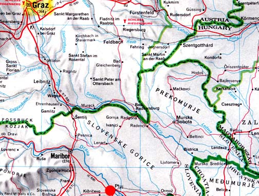
June 7, 2007 Ptuj, Slovenia - Today I received an email from Omer Sabic in Slovenia, a country bordered by Austria, Hungary, Croatia and Italy.

June 7, 2007 Ptuj, Slovenia - Today I received an email from Omer Sabic in Slovenia, a country bordered by Austria, Hungary, Croatia and Italy.
"The physical data knocks out the chance that people hoaxed this. People just cannot hoax the expulsion cavities and they cannot elongate the growth nodes..."
- Jeffrey Wilson, ICCRA
Return to Part 1: U. S. Crop Formations in Epps, Louisiana, and Red Bluff, Calif.
Return to Part 2: U. S. Crop Formations, Two Mysterious Grass Circles in Mission, Kansas.
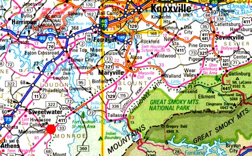
June 7, 2007 Williamsburg, Ohio - On May 24, 2007, I received a phone call from Jeffrey Wilson, Director of the Independent Crop Circle Research Association (ICCRA) in Williamsburg, Ohio, telling me that the Monroe County Buzz newspaper in Madisonville, Tennessee, had a headline about a crop formation in a wheat field. Madisonville, Monroe County, Tennessee - site of the historic Cherokee nation's capital, Chota - is straight south of the Oak Ridge National Laboratory outside Knoxville and west of the Great Smoky Mountains (red circle on map).
Return to Part 1: Yatesbury Spiral - Viewer Comments on Spiral Math
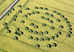
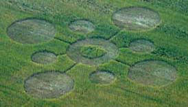
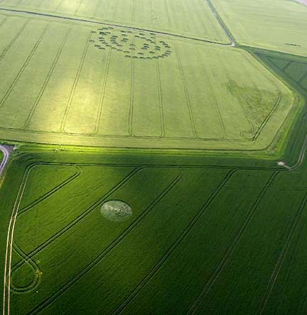
June 6, 2007 Yatesbury Field, Wiltshire, England - Two crop formations an ocean apart - one in English barley near the ancient and sacred ground of Avebury Trusloe on Yatesbury Field; the other in a Madisonville, Tennessee, wheat field not far from the historic Cherokee Indian capital of Chota and even more ancient 9,500-year-old Icehouse Bottom. (See Part 3: Madisonville Circles.) The English pattern has fifty-seven circles threaded on a thin, 4-inch-diameter spiral. The Tennessee pattern has nine circles with a triangular "pointer" in the middle standing circle that aims west in the opposite direction from Chota.
"Something has really knocked the heck out of the energy in the larger circle – and somewhat in the smaller circle."
- W. C. Levengood, Biophysicist

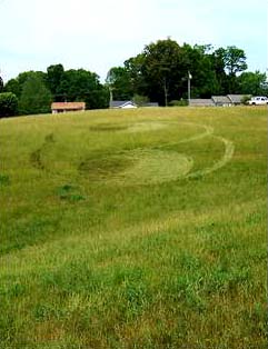
June 5, 2007, Earthfiles viewer's comment on the Mission, Kansas, grass circles:
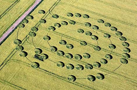
June 4, 2007 Albuquerque, New Mexico - So many Earthfiles readers today were provoked by the Yatesbury Field spiral "abacus" and the single circle in the other field that seems to reinforce the importance of the number "1" in the spiral counting. Among the many emails was communication from Chris Steele of ICCRA (Independent Crop Circle Research Association).
“It’s not really so much of a question whether the dangerous tipping point occurs at 450 or 550 ppmv CO2. It’s how do we get the (greenhouse) emissions under control so we don’t push past all the possible points at which the climate change becomes a seriously dangerous issue.”
- Chris Field, Ph.D., Director, Carnegie Institution's Dept. of Global Ecology, Stanford University, Palo Alto, Calif.
June 1, 2007 New York, New York - The United Nations Intergovernmental Panel on Climate Change reported this year that there is at least a 90% certainty that global warming is man-made and will “continue for centuries.” The IPCC also reports that in coming decades, rising temperatures and rising sea levels will cause floods and mass famine. The implication is that there will be massive dislocations of humans and animals that have traditionally lived near coastlines. Despite the hard data, the George Bush Administration has resisted setting CO2 reduction goals, claiming there would be too many economic hardships for Americans. Ironically, it is the United States, which dominates the world list of greatest CO2 emitters.
May 30, 2007 Albuquerque, New Mexico - Here begins an overview of five American crop formations, all in the month of May 2007. Each one is near Native American and ancient earth mounds reminiscent of the closeness that Wiltshire, England, crop formations also have to ancient stone circles and earth mounds.
Home of Cherokee Indians; many earth mounds west of Asheville.
More upcoming in Part 4.

Return to 05/15/07: Odd Aerial "Drone?" Over Lake Tahoe and Central California
Return to 05/16/07: Engineer Comments About Odd Aerial "Drone?" Earthfiles.
Return to 05/16/07: Odd Aerial "Drone"? Photographed Again Over Capitola, CA.
Return to 05/25/07: Two More Eyewitnesses of Aerial "Drones" in 2005 and 2006.
Return to 05/28/07: Letters About Unidentified "Drone" Aerial Objects.
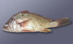
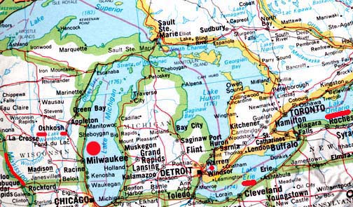
May 29, 2007 Madison, Wisconsin - The Wisconsin Department of Natural Resources reported on May 24, 2007, that a brown trout that died in Lake Michigan and washed ashore near the Kewaunee/ Algoma area preliminarily tested positive for viral hemorrhagic septicemia, or VHS. The University of Wisconsin-Madison Wisconsin Veterinary Diagnostic Laboratory conducted the preliminary test on the Lake Michigan trout. The sample has been sent to an Ames, Iowa, lab to confirm the VHS findings.The deadly fish disease also spread earlier this month to Lake Winnebago fish in eastern Wisconsin.