Part 1: Why No Military Response to Radar Unknown Headed to Bush Crawford Ranch on January 8, 2008?

“When radar returns on one unknown object (no transponder beeps) did show up in the data from 6:51 PM to 8:00 PM, on our graph it was traveling a straight line headed for Crawford, Texas.”

- Glen Schulze, Electrical Engineer and Radar Specialist


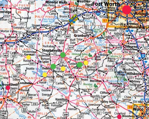
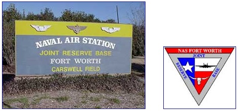
A triangle of three small towns (green) southwest of Fort Worth includes Stephenville, a city in and the county seat of Erath County, Texas, population 14,921 in 2000 census. Dublin, about eight miles southwest, has a population of 3,754. Straight east of Dublin about ten miles is Selden with a full time population of about seven. The Brownwood Military Operations Area (MOA) is further southwest in map's lower left red circle. The red circle in lower right corner of map is Crawford, Texas, ranch home of U. S. President George W. Bush.  The Naval Air Station Joint Reserve Base at Carswell Field is five miles west of downtown Fort Worth, large red circle in upper map right. The four yellow circles at Gorman, Proctor Lake, Alexander and Chalk Mountain are UFO eyewitness locations on January 8, 2008, in addition to several other eyewitnesses in the green circles of Stephenville, Dublin and Selden, Texas.
Naval Air Station Joint Reserve Base Fort Worth or NAS JRB Fort Worth, also known as Carswell Field, is now home to the U. S. Navy Reserve, U. S. Marine Corps Reserve, U. S. Air Force Reserve, and U. S. Air National Guard. The Carswell military complex is a military airfield located five miles (8 km) west of the central business district of Fort Worth, in Tarrant County, Texas, United States. This military airfield is operated by the United States Navy. The Air Force Reserve Command's Tenth Air Force headquarters and 301st Fighter Wing continue to be based at the installation, as well as the 136th Airlift Wing of the Texas Air National Guard. A number of Marine Corps aviation and ground units are also co-located at NAS JRB Fort Worth. Currently based Air Force aircraft are the F-16 Fighting Falcon and C-130 Hercules. Currently based Marine Corps aircraft are the F/A-18 Hornet and KC-130 Hercules. See: NAS JRB Fort Worth.
Naval Air Station Joint Reserve Base Fort Worth or NAS JRB Fort Worth, also known as Carswell Field, is now home to the U. S. Navy Reserve, U. S. Marine Corps Reserve, U. S. Air Force Reserve, and U. S. Air National Guard. The Carswell military complex is a military airfield located five miles (8 km) west of the central business district of Fort Worth, in Tarrant County, Texas, United States. This military airfield is operated by the United States Navy. The Air Force Reserve Command's Tenth Air Force headquarters and 301st Fighter Wing continue to be based at the installation, as well as the 136th Airlift Wing of the Texas Air National Guard. A number of Marine Corps aviation and ground units are also co-located at NAS JRB Fort Worth. Currently based Air Force aircraft are the F-16 Fighting Falcon and C-130 Hercules. Currently based Marine Corps aircraft are the F/A-18 Hornet and KC-130 Hercules.

July 26, 2008  Littleton, Colorado - Back in early January to mid-February 2008, a series of unidentified aerial lights and strange craft were reported by dozens of eyewitnesses in the Stephenville, Dublin, and Selden region southwest of Dallas/Fort Worth, Texas. One especially active date was January 8, 2008, beginning a few minutes after 6 PM Central with three eyewitnesses sitting on a hill in Selden southeast east of Stephenville and straight east of Dublin.


Click here to subscribe and get instant access to read this report.

Click here to check your existing subscription status.

Existing members, login below:

Part 3:  Roswell Rock Lab Analysis

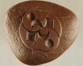
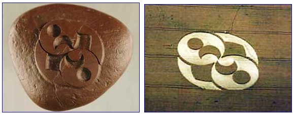
“The pattern is remarkable. Obviously, it is something that took a lot of care and knowledge to produce because this hard, iron-rich sandstone with magnetite is not easily worked.”

- James Constantopoulos, Ph.D., Geologist

Left:  Mysterious 1.96 inches (5-centimeters) by1.69 inches (4.3-centimeters) diameter rock that weighs 50.78 grams, measured on July 15, 2008, in Physical Sciences Department at Eastern New Mexico University. The carved rock was found by Roswell auto repairman, Robert Ridge, 50, during his September 4, 2004, deer hunting trip near Capitan, New Mexico, 17 miles southeast from the July 1947 UFO crash site between Corona and Roswell. Image by Robert Ridge.   Right:  Wheat formation, 120 feet long, reported August 2, 1996, below the Liddington Castle hill fort in Chisledon, near Swindon, Oxfordshire, England, on Wiltshire County border. Aerial image © 1996 by Steve Alexander.   Also see:  Cropcircleconnector.com.
Above:  Mysterious 1.96 inches (5-centimeters) by1.69 inches (4.3-centimeters) diameter rock that weighs 50.78 grams, measured on July 15, 2008, in Physical Sciences Department at Eastern New Mexico University. The carved rock was found by Roswell auto repairman, Robert Ridge, 50, during his September 4, 2004, deer hunting trip near Capitan, New Mexico, 17 miles southeast from the July 1947 UFO crash site between Corona and Roswell. Image by Robert Ridge.   Below:  Wheat formation, 120 feet long, reported August 2, 1996, below the Liddington Castle hill fort in Chisledon, near Swindon, Oxfordshire, England, on Wiltshire County border. Aerial image © 1996 by Steve Alexander.   Also see:  Cropcircleconnector.com.


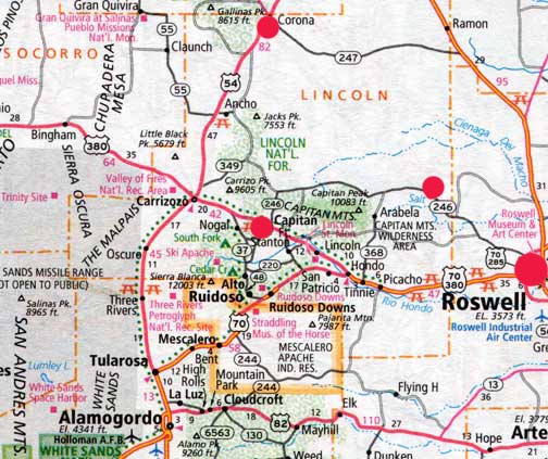
Roswell is larger red circle on far right. Cedar Hill deer hunting trail is smaller red circle on Highway 246 (Pine Lodge Road) just west of Chavez and Lincoln County borders northwest of Roswell. Capitan is middle red circle and Corona is top center of map. Cedar Hill deer trail is 17 miles southeast of the July 4, 1947, crash site between Corona and Roswell.

Return to Part 1

July 18, 2008  Portales, New Mexico - I contacted the original geologist in Portales who did the first February 2005 energy-dispersive X-ray fluorescence spectroscopy on the rock for Robert Ridge. I learned that all the original test results had been lost a couple of years ago in a computer hard drive crash. So, on Tuesday, July 15, 2008, I drove to Portales, New Mexico, to meet Robert for a second round of testing of the mysterious carved rock at the Physical Sciences Department of Eastern New Mexico University. The Chair of that department is Geology Professor James Constantopoulos, Ph.D., who has taught at ENMU for nearly twenty years. Prof. Constantopoulos began by examining the rock using a binocular microscope.


Click here to subscribe and get instant access to read this report.

Click here to check your existing subscription status.

Existing members, login below:

Astronomical Data in July 2008 U. K. Crop Formations?

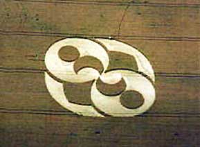
“At Avebury Manor on July 15, 2008, all nine planets appear there precisely as they will be located in space four and one-half years from now on December 23, 2012, with one exception.”

- “Red Collie,” Australian Scientist


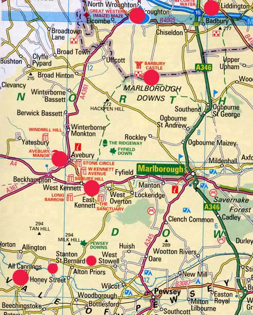
Red circles match geographical locations for Wiltshire, England, crop formations listed below. Note that Liddington in far upper right is also in the Oxfordshire map at bottom of report for overview reference.

July 16, 2008  Wiltshire and Oxfordshire, England -

For all crop formations listed in this report, also see:  Cropcircleconnector.com.

July 1, 2008

The Sanctuary, All Cannings near Avebury, Wiltshire:


Click here to subscribe and get instant access to read this report.

Click here to check your existing subscription status.

Existing members, login below:

Part 1:  Roswell “Rock” Matches August 2, 1996, U. K. Crop Pattern.

“Nine times out of ten when I put a magnet over the top of the pattern side of the rock, the rock wants to spin counter-clockwise.”

- Robert L. Ridge, Roswell, NM

Left:  Mysterious 1.96 inches (5-centimeters) by1.69 inches (4.3-centimeters) diameter rock that weighs 50.78 grams, measured on July 15, 2008, in Physical Sciences Department at  Eastern New Mexico University. The carved rock was found by Roswell auto repairman,  Robert Ridge, 50, during his September 4, 2004, deer hunting trip near Capitan,  New Mexico, 17 miles southeast from the July 1947 UFO crash site between Corona and Roswell. Image by Robert Ridge.   Right:  Wheat formation, 120 feet long,  reported August 2, 1996, below the Liddington Castle hill fort in Chisledon,  near Swindon, Oxfordshire, England, on Wiltshire County border.  Aerial image © 1996 by Steve Alexander.   Also see:  Cropcircleconnector.com.
Left: Mysterious 1.96 inches (5-centimeters) by1.69 inches (4.3-centimeters) diameter rock that weighs 50.78 grams, measured on July 15, 2008, in Physical Sciences Department at Eastern New Mexico University. The carved rock was found by Roswell auto repairman, Robert Ridge, 50, during his September 4, 2004, deer hunting trip near Capitan, New Mexico, 17 miles southeast from the July 1947 UFO crash site between Corona and Roswell. Image by Robert Ridge. Right: Wheat formation, 120 feet long, reported August 2, 1996, below the Liddington Castle hill fort in Chisledon, near Swindon, Oxfordshire, England, on Wiltshire County border. Aerial image © 1996 by Steve Alexander. Also see: Cropcircleconnector.com.


July 11, 2008  Roswell, New Mexico - On September 4, 2004, Roswell self-employed auto shop owner, Robert L. Ridge, decided to go bow and arrow hunting for deer in Cedar Hill near Capitan Mountain, about 17 miles southwest of the alleged UFO crash of a wedge-shaped aerial vehicle between Corona and Roswell sixty-one years ago in July 4 to July 6, 1947. He has lived in Roswell the entire fifty years of his life and many times before had traveled to Cedar Hill to hunt deer.


Click here to subscribe and get instant access to read this report.

Click here to check your existing subscription status.

Existing members, login below:

More Military Sightings of UFOs in U. K.

“I could see thirteen craft in the skies. They were zig-zagging, but I filmed two before they disappeared. They were like rotating cubes with multiple colours.”

- Corporal Mark Proctor, 1st Battalion Irish Regiment, June 7, 2008

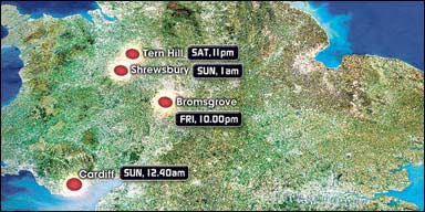
The Sun, Wednesday, June 25, 2008, headline. To see cell phone videos , The Sun.

“They weren't from this world. They made no sound and had flashing dots inside.”

- Bonnie Lewis, Bromsgrove, Worcestershire,
U. K., June 20, 2008

Bonnie Lewis, 29, videotaped seven cylinder-shaped aerial objects over Bromsgrove, Worcestershire, U. K. with her cell phone on Friday, June 20, 2008.
Saturday, June 7, 2008, at 11 PM, Tern Hill barracks near Market Drayton, Shropshire, where thirteen spinning cubes or cylinders were taped on cell phone by military; Sunday, June 8, 2008, at 12:40 AM, police helicopter nearly collides with disc-shaped craft near Cardiff, Wales; Sunday, June 8, 2008, at 1 AM in Shrewsbury, a couple said they were followed by a strange light in the sky along the A5; Friday, June 20, in Bromsgrove, Worcestershire, 29-year-old Bonnie Lewis videotaped seven spinning, cylinder-shaped aerial objects on her cell phone. Map © 2008 by The Sun.

June 27, 2008  Shropshire and Bromsgrove, United Kingdom - On Friday, June 20, 2008, only a few days ago, a 29-year-old British woman named Bonnie Lewis from Bromsgrove, Worcestershire, was walking her dog when she saw four spinning, multi-colored cylinders in the sky, which astonished Bonnie. She grabbed her cell phone and took video of the spinning cylinders.


Click here to subscribe and get instant access to read this report.

Click here to check your existing subscription status.

Existing members, login below:

Updated June 25, 2008: Increasingly Acidic Pacific Coast Waters Threaten Marine Life

“We have already seen in 2007 a drop in pH of 0.1,  which equates to ~30% increase in acidity. By the end of this century  the models predict a total drop in pH of 0.4 which is actually more  like a 150% increase in acidity. For ocean chemistry, this is very dramatic –  a bigger change than we’ve seen for at least the last 5 million years on planet Earth. And it’s more than 100 times faster rate of change than we’ve seen over that period.”

- Christopher Sabine, Ph.D., NOAA


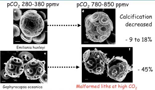
Coccolithosphores, single-celled algae, that contain calcium carbonate shells. When exposed to acidic water equivalent to the 800 ppm upwelling ocean samples in 2007 off the California coast, the Coccolithosphores become malformed and deteriorate. Images by Riebesell and Zondervan in 2000 and 2001.

June 21, 2008  Corvallis, Oregon and Shelton, Washington - None of the global warming climate models saw open oceans increasing in acidity by 30% or more until the end of the 21st Century. But a new study published in the June 2008 journal, Science, shows that Pacific ocean water only four miles off the northern California shore, is already 30% more acidic than normal. When I did my first Earthfiles.com report about the acidification of the world’s oceans [ 081304 Earthfiles ], computer models were projecting that open ocean acidity might seriously increase by at least 30% or more at the end of the 21st Century - not by 2008.


Click here to subscribe and get instant access to read this report.

Click here to check your existing subscription status.

Existing members, login below: