More than 100 million gallons of crude oil from British Petroleum's unplugged drill hole might already have spewed into the Gulf of Mexico. On June 11, 2010, scientists estimated the BP blown-out well a half mile down in the Gulf could have been spewing as much as 2 million gallons of crude a day until the BP cut-and-cap that is now siphoning off some of the gushing oil. [ 35,000 to 60,000 barrels a day = 1.5 to 2.5 million gallons a day.]
“The BP oil spill threatens a number of power plants.
If the water supply for these facilities becomes contaminated
with oil, cooling water systems could be damaged.”
- U. S. Dept. of Energy May 12, 2010 Situation Report
Sea bird covered with British Petroleum oil in June 2010 on Louisiana shore after BP's Deepwater Horizon drilling unit blew up on April 20, 2010, releasing as much as 2 million gallons of crude oil every day up to BP's recent cut-and-cap maneuver that began capturing some of the oil flow. [ 35,000 to 60,000 barrels a day = 1.5 to 2.5 million gallons a day.] Image by Louisiana Dept. of Wildlife and Fisheries.June 12, 2010 Harrisburg, Pennsylvania - At approximately 11:00 PM EDT on April 20, 2010, an explosion occurred aboard British Petroleum's (BP) Deepwater Horizon mobile offshore drilling unit (MODU) located 52 miles southeast of Venice, Louisiana, and 130 miles southeast of New Orleans. Eleven men working the oil rig died. BP was drilling an exploratory well at the time of the incident. By June 11, 2010, scientists trying to give a reality check on how much oil has erupted from the disastrous mile-deep drill hole stunned the U. S. and the world with an estimate as high as 2 million gallons of crude oil a day, turning the Gulf of Mexico into a toxic marineland and destroying the birds, animals and plant life that live in the delicate wetlands bordering the Gulf shores in Texas, Louisiana, Mississippi, Alabama, western Florida and potentially even the east coast of Florida if enough oil gets into the loop current that goes around the southern tip of Florida and back up the East Coast.
Click here to subscribe and get instant access to read this report.
Click here to check your existing subscription status.
“Quite remarkably, planet Earth and Moon will lie precisely between the two Comet McNaught tracks, incoming or outgoing, close to comet perihelion [ July 2, 2010].”
June 11, 2010 Stony Littleton Long Barrow near Wellow, Somerset, England - Last September 2009, a new comet was discovered by Australian astronomer Robert McNaught. This is the 51st comet to bear comet-seeker McNaught's name. And now ten months later as Comet McNaught is finally becoming visible to the naked eye, an unusual crop formation in beans was reported on June 7, 2010, not far from the Stony Littleton Long Barrow near Wellow, Somerset, England. Australian scientist and crop pattern analyzer, Red Collie, thinks there is a link between the new comet and the new bean formation.
Click here to subscribe and get instant access to read this report.
Click here to check your existing subscription status.
“Who, or what, could overwhelm a 1500-pound cow, transport her from the pasture for the various tissue removals, and then return her to a grove of trees without nearby residents hearing or seeing something?”
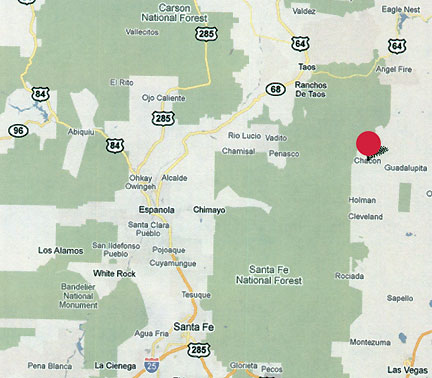
Chacon and Mora, New Mexico, are remote ranching communities marked by the red circle about 50 miles northeast of Santa Fe.
June 10, 2010 Chacon, New Mexico - Biophysicist W. C. Levengood found cellular changes in the plants I sampled from the Chacon, New Mexico, mutilation and “floating” cow site that suggested exposure to microwave frequencies. He had found similar changes at other mutilation sites such as Garnett, Kansas, in June 1994. About that Garnett, Kansas case, biophysicist Levengood's lab report, “Crop Formation Associated with a Cattle Mutilation,” is included in More Information below.
Click here to subscribe and get instant access to read this report.
Click here to check your existing subscription status.
“That cow was being dragged sideways somehow with its legs
touching the ground. The cow's back was moving toward the weird,
loud sound and the cow could not move its legs to get up.”
- Larry Gardea, Carpenter, Chacon, New Mexico
Chacon, New Mexico, is a remote ranching community about 50 miles northeast of Santa Fe.
June 7, 2010 Chacon, New Mexico - Northeast of Santa Fe, New Mexico, across the Carson and Santa Fe National Forests is the small and very rural ranching community of Chacon. Around Chacon rise mountains to 10,000-foot-peaks. There are only a few hundred farm residents who depend on each other to survive. They watch their pastures, the mountains and the sky for any signs of trouble.
Click here to subscribe and get instant access to read this report.
Click here to check your existing subscription status.
June 4, 2010 Liddington Castle near Swindon, Wiltshire, England - Today I received the following email from Red Collie, an Australian scientist who collaborates with astronomer Mike Reed in the United States and other crop investigators in Italy and elsewhere. For the past few years, Red Collie finds continual references in crop formations to lunar and solar eclipses and other astronomical relationships. When he examined the June 2, 2010, circular pattern in Barley at Liddington Castle, he thinks there is a link to the upcoming June 26, 2010, partial lunar eclipse - and possibly a relationship to the Mayan Long Count calendar.
Click here to subscribe and get instant access to read this report.
Click here to check your existing subscription status.
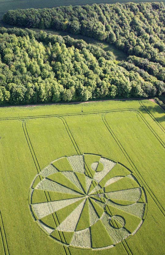
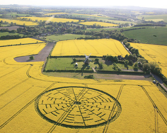
“You see the windmill and see the circle and they seem connected. And then to see Euler’s equation relating to the circular idea just fitted in beautifully with it! So, I was mightily impressed with the whole design!”
June 1, 2010 Guildford, Surrey, England - Richard Andrews was staring at Lucy Pringle's aerial photograph (above) on his computer screen after midnight on Sunday, May 23, 2010. Richard is a freelance web designer and administrator who was born 46 years ago in Henley-on-Thames in Oxfordshire county about thirty miles west of London. After high school in 1982, Richard first worked for a year on a degree in environmental psychology at the University of Surrey. Then he went to Africa to work on a game reserve. By 1994, he had earned a Diploma in Heritage Interpretation from the University of London's Birkbeck College. He's currently writing a book entitled The Temple of the Grail, which he plans to publish in the near future. Richard is also an administrator for DailyGrail.com owned by Greg Taylor, a website that explores the edges of science and history, including the worldwide phenomenon of crop formations.
Click here to subscribe and get instant access to read this report.
Click here to check your existing subscription status.
“I have tried to stand on a mature oilseed rape stem
and that plant will crack, will snap, at the base. ...There were
lots of stems in the Wilton Windmill formation flattened close to the
ground without any breakage.”
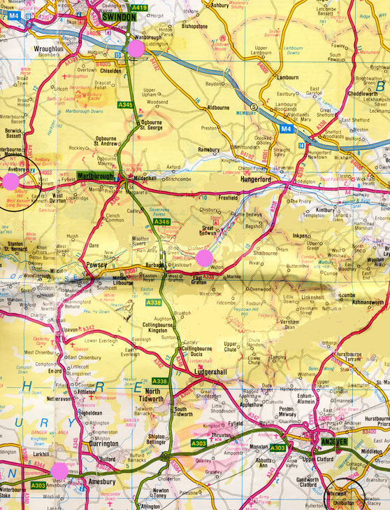
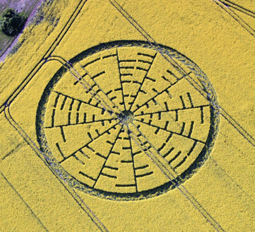
June 3, 2010 Wilton, Wiltshire, England - Two English researchers and videographers got to the Wilton Windmill formation within hours after the first report around noon on Saturday, May 22, 2010, by pilot Busty Taylor. The first one in was 44-year-old Gary King who moved from the Cardiff region to Wiltshire County two and a half years ago after being present during a night to sunup hillside nightwatch on July 7, 2007. To his astonishment, in the 3:45 AM early dawn, a large pattern with at least 150 circles was visible in the East Field when there had been no formation the day before. He had been intrigued by crop formations since 1997, but that 07-07-07 East Field event turned him into a passionate investigator. “My life has never been the same since then,” Gary told me. [ See 071407 Earthfiles in Archive.]
Click here to subscribe and get instant access to read this report.
Click here to check your existing subscription status.
“The moving aerial object struck my attention because it was slightly darker blue than the sky and triangular-shaped.”
- Ohio traveler
May 30, 2010 Albuquerque, New Mexico - After my May 27-28, 2010, Earthfiles and Coast to Coast AM radio news updates that included recent unidentified aerial lights, triangle and falling bits of light over the town of Weslaco, Texas [ See: 052810 Earthfiles], I received the following viewer and listener emails that I feel are important for general audience consideration. I also urge others who might have experienced or seen any similar events to contact [email protected]. Earthfiles does not share names, email address or other contact information without permission.
Click here to subscribe and get instant access to read this report.
Click here to check your existing subscription status.
“Everybody was taken completely by surprise because
there had been no cases prior to 1999 of Cryptococcus gattii in the
Northern Hemisphere and suddenly, there were a whole series
of cases occurring in both humans and animals.”
- Joseph Heitman, M. D., Molecular Geneticist, Duke Univ. Med. Center
Cryptococcus gattii basidia and spores. Photomicrograph provided by Joseph Heitman, M. D. and Ph.D., Molecular Geneticist, Duke University Medical Center.
May 27, 2010 Durham, North Carolina - Recently Web MD and other internet medical sites have featured articles with headlines such as, “About 10 People Have Reportedly Died in Northwestern U.S. After Infection with C. Gatti. [sic]” Cryptococcus gattii is a soil and plant fungus species usually found in South America, Australia, Africa and New Guinea. That particular fungus was not discovered in North America before 1999 when clinicians on the island of Vancouver, B. C., Canada, in the southeastern cities of Victoria and Nanaimo, confirmed emergency room patients with pneumonia and meningitis were infected with C. gattii fungus.
Click here to subscribe and get instant access to read this report.
Click here to check your existing subscription status.
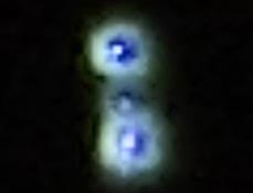
“From the big blue light, these smaller ‘sparks’
kind of floated downward on to Weslaco. Then I looked
up at the blue light and it dissipated, ate itself up (from the outside
into blackness).”
- Jose Gonzalez, College Student, Weslaco, Texas
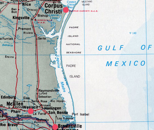
Digital frame 2666 photographed by Jose Gonzalez, February 28, 2010, around 10 PM Central, Weslaco, Texas.Weslaco is a city of about 27,000 people in Hidalgo County, Texas, some 60 miles west of Padre Island and the Gulf of Mexico. Corpus Christi is north and Brownsville is a few miles southeast.


![Sea bird covered with British Petroleum oil in June 2010 on Louisiana shore after BP's Deepwater Horizon drilling unit blew up on April 20, 2010, releasing as much as 2 million gallons of crude oil every day up to BP's recent cut-and-cap maneuver that began capturing some of the oil flow. [ 35,000 to 60,000 barrels a day = 1.5 to 2.5 million gallons a day.] Image by Louisiana Dept. of Wildlife and Fisheries.](https://www.earthfiles.com/wp-content/uploads/2017/10/OilSpillBirdOnBackLaJune2010.jpg)