Updated: Why Is NASA Faking Gale Crater Images On Mars?

“Since we know that the Google Mars image is older, and of higher
resolution than the fake Photoshopped image, then perhaps as it got closer to the Curiosity Landing date, and the Mars Orbiter was used to take more photos of the Curiosity landing zone ... perhaps NASA saw something that hadn’t been in earlier photos ... and needed to be covered up.”

 - Retired U. S. Navy Captain

“I find it interesting that in Google Earth->Mars, there are two high-resolution image strips of the Curiosity landing area with a big gap between them, and that whatever they're hiding falls in that gap.”

- Daniel
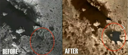
 

The original Martian Gale crater aerial image on the left was taken by a Mars-orbiting spacecraft and distributed by NASA/JPL. There is no "lake"  with appendages. But in a later NASA/JPL image on the right, for unknown reasons,  the "lake" with appendages has been pasted in to cover up what?  Further, the "lake" was copied and retouched from an actual feature on a high-resolution NASA image discussed below. Source images by NASA/JPL.
The original Martian Gale crater aerial image on the left was taken by a Mars-orbiting spacecraft and distributed by NASA/JPL. There is no "lake" with appendages. But in a later NASA/JPL image on the right, for unknown reasons, the "lake" with appendages has been pasted in to cover up what?  Further, the "lake" was copied and retouched from an actual feature on a high-resolution NASA image discussed below. Source images by NASA/JPL.

Editorial Note: The word "lake" in quotation marks is used throughout this Earthfiles report to denote the darker, lake-like patterns, but does not literally mean liquid water, which cannot last long on the surface of Mars without sublimating into the atmosphere. Speculation is that the darker colored patterns that resemble lakes are mineral residues that are currently unidentified on what appear to be the bottoms of ancient lake beds.
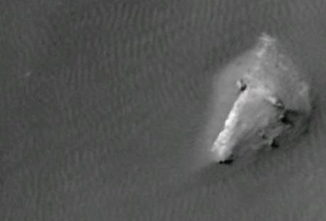
 Extreme close up on the Gale Crater "lake pattern" discussed in this report to show the ripple patterns of the presumed ancient lake bed surrounding the three "islands"  in the "lake," including this largest "island" that was retouched out of the copy/paste digital manipulation of the Gale crater landscape described  in this Earthfiles report. Image source NASA/JPL.
Extreme close up on the Gale Crater "lake pattern" discussed in this report to show the ripple patterns of the presumed ancient lake bed surrounding the three "islands" in the "lake," including this largest "island" that was retouched out of the copy/paste digital manipulation of the Gale crater landscape described in this Earthfiles report. Image source NASA/JPL.

Updated September 24, 2012  Albuquerque, New Mexico - On September 21, I received an email with the following YouTube URL posted on September 19, 2012, by “SunsFlare.” I was asked to view what was described as deliberately faked Gale Crater images on Mars. Gale Crater is where the Curiosity Mars Science Lab rover landed on August 5, 2012, at 10:31 PM Pacific to explore for evidence of water and chemistry of life on the Red Planet.


Click here to subscribe and get instant access to read this report.

Click here to check your existing subscription status.

Existing members, login below:

Part 4:  “Dark Pyramid” Underground in Alaska, Bruce Pearson’s Navy Father

Updated with mp3 interview.


“This is as super secret a situation as the Manhattan Project was. Nobody is supposed to know this place even exists. ...This thing is some kind of power generator and it’s thousands of years old, it’s made out of stone like a pyramid. They don’t know where it came from, who made it or how it works. But it can generate enough power to power the whole North Slope, all of Alaska, and probably the whole country of Canada!”

- USAF Huey pilot to Bruce Pearson's father

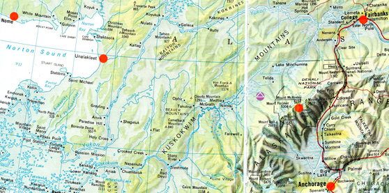
This map shows Nome far upper left; then Unalakleet on eastern edge of Norton Sound; then purple circle with white pyramid at the latitude and longitude west of Mt. McKinley (red circle) where retired Navy Captain reported finding a “square” anomaly in the landscape that could be the site of a large underground pyramid.

Return to Part 1.

Updated September 16, 2012, with mp3 / Original September 10, 2012  Albuquerque, New Mexico -

Helicopter Flight from Unalakleet
to Underground Pyramid Site
Late April or Early May 1978

On September 3, 2012, I received a long email from yet another son about his father's firsthand knowledge of an underground pyramid approximately two hours east of Unalakleet by Huey helicopter in the late April or early May 1978 time frame. The son gave me permission to use his full real name, Bruce L. Pearson. Bruce, 55, is Chief Executive Officer for Broadcastvenue.com and does reporting for HD Media Production in Clinton, New Jersey.


Click here to subscribe and get instant access to read this report.

Click here to check your existing subscription status.

Existing members, login below:

Part 3:  “Dark Pyramid” Underground in Alaska, Bruce Pearson’s Navy Father

“The pilot told my dad the Alaska site was ‘every bit as hush hush as the Manhattan Project.’ ...The pilot also told him that it was not a nuclear device; it was not made by man;  it was an incredibly old pyramid and they had no idea where it came from or how it was built underground of cut stone; and it was capable of producing enough energy to power the whole North Slope, all of Alaska and most, if not all, of Canada!”

- Bruce Pearson, New Jersey

“Bill” had been in an underground base or facility that had been built there in Alaska for the purpose of working on ‘alien’ technology and biology.”

- August 26, 2012 email to Earthfiles


This map shows Nome far upper left; then Unalakleet on eastern edge of Norton Sound; then purple circle with white pyramid at the latitude and longitude west of Mt. McKinley (red circle) where retired Navy Captain reported finding a “square” anomaly in the landscape that could be the site of a large underground pyramid.

Return to Part 1.

September 6, 2012  Albuquerque, New Mexico - The alleged underground pyramid structure west of Mount McKinley continues to provoke email since my original Earthfiles and Coast to Coast radio interview with Doug Mutschler, retired U. S. Army Counterintelligence Warrant Officer, with information about an underground pyramid was posted on July 26, 2012. See: Updated Parts 1 - 3: 072712 Earthfiles.


Click here to subscribe and get instant access to read this report.

Click here to check your existing subscription status.

Existing members, login below:

Part 2:  “Dark Pyramid” Underground in Alaska

“...the Ballistic Missile Early Warning System (BMEWS) construction
could have been used as a cover up for the assembly of a group of highly technical people to all of a sudden leave their families and jobs in the States to fly to Alaska.”

- Retired Navy Captain


This map shows Nome far upper left; then Unalakleet on eastern edge of Norton Sound; then purple circle with white pyramid at the latitude and longitude west of Mt. McKinley (red circle) where retired Navy Captain reported finding a “square” anomaly in the landscape that could be the site of a large underground pyramid.

Return to Part 1.

September 2, 2012  Albuquerque, New Mexico - The alleged underground pyramid structure west of Mount McKinley has provoked a lot of email since my original Earthfiles and Coast to Coast radio interview with Doug Mutschler, retired U. S. Army Counterintelligence Warrant Officer, with information about an underground pyramid was posted on July 26, 2012. See: Updated Parts 1 - 3: 072712 Earthfiles.


Click here to subscribe and get instant access to read this report.

Click here to check your existing subscription status.

Existing members, login below:
Missouri Man Has Shot Two “Chupacabras”

“The creature slowed  down and stood up on its back legs -
its back legs were longer than its front legs - and as it stood
up its head turned and it looked straight at us.”

- Jami Ham, Medical Technician, Poplar Bluff, Missouri

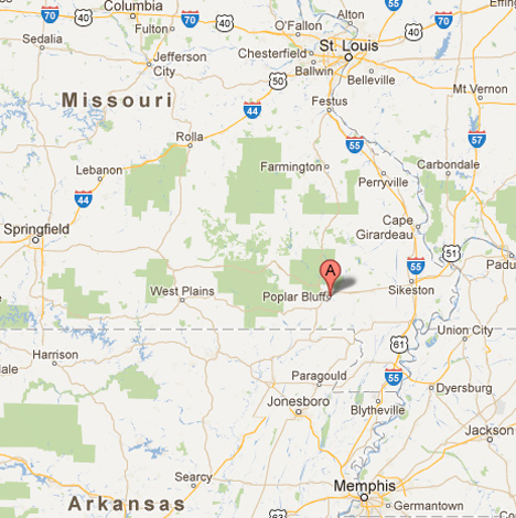
Poplar Bluff, Missouri, is 153 miles south of St. Louis not far from the Tennessee border with a population of some 17,000 residents on the Black River.

August 31, 2012  Poplar Bluff, Missouri - In the spring of 1995, farmers in the El Junque rainforest region of Puerto Rico reported finding chickens, rabbits, goats, sheep and even dogs with quarter-inch wide puncture holes that did not bleed, but usually left the victimized domestic animals dead as if the blood had been sucked out of them. That description lead to the name “chupacabras,” which means “goat sucker” in Spanish.


Click here to subscribe and get instant access to read this report.

Click here to check your existing subscription status.

Existing members, login below:

Two 2012 U. K. Crop Formations of High Strangeness

“The recorded effect of severe node bending, when seen on day one, is not the effect of phototropism or similar natural processes. The delivery system employed in the creation of this circle remains a mystery.”

- Charles Mallett, Silent Circle.com.


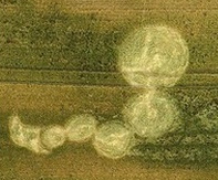
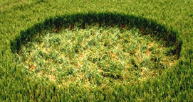
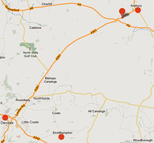
Top: Knoll Down, Beckhampton, Wiltshire, England, reported June 26, 2012. Aerial © 2012 by Henry F. Mac. Bottom: Etchilhampton Hill, Etchilhampton, Wiltshire, England, reported July 12, 2012. Etchilhampton Pole Photography  © 2012 by Eva Marie Brekkestoe.
Top: Knoll Down, Beckhampton, Wiltshire, England, reported June 26, 2012. Aerial © 2012 by Henry F. Mac.
Bottom: Etchilhampton Hill, Etchilhampton, Wiltshire, England, reported July 12, 2012. Etchilhampton Pole Photography © 2012 by Eva Marie Brekkestoe.

The upper right map pointer is highlighting Knoll Down, Wiltshire, England, not far from the ancient stone circles of Avebury and Europe's tallest manmade mound,  Silbury Hill. Southwest by about 12 miles as the crow flies is Etchilhampton Hill (bottom red circle).
The upper right map pointer is highlighting Knoll Down, Wiltshire, England, not far from the ancient stone circles of Avebury and Europe's tallest manmade mound, Silbury Hill. Southwest by about 12 miles as the crow flies is Etchilhampton Hill (bottom red circle).

August 31, 2012  Wiltshire, England - Mysterious crop circles associated with balls of light moving in the air across fields have been reported in England since at least World War I. The modern age of crop formations emerged in the late 1970s around Warminster, England, and evolved through the 1980s from single circles to simple patterns of a few circles to the astonishing geometries, fractals and other complex patterns from the 1990s into the 21st Century.


Click here to subscribe and get instant access to read this report.

Click here to check your existing subscription status.

Existing members, login below:

Cattle Mutilations in Montana, Colorado, Idaho and Argentina

“When I did the necropsy, the heart, pericardium sac, vulva and roof of the vagina had been surgically removed.”

- Beth M. Blevins, D.V.M., Ronan, Montana


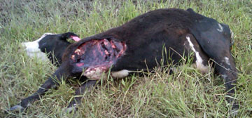
3-year-old Angus-cross cow found dead on June 27, 2012, near Ronan, Montana, 40 miles north of Missoula, with bloodless, “surgical excisions” from her hide and removal of her heart, pericardium sac, vulva genital tissue and roof of vagina. Images by Lake County Sheriff's Department and Valley Journal.

August 30, 2012  Ronan, Montana- Since May 2012, the following horse and cattle mutilations have been reported in Colorado, Montana and Idaho; and since July 2012, dozens of cattle and horse mutilations have been reported in Argentina (further below).


Click here to subscribe and get instant access to read this report.

Click here to check your existing subscription status.

Existing members, login below:

Update:  Baltic Sea Mystery Object

“My hypothesis is that this object, this structure, was formed
during the ice age many thousands of years ago.”

- Volker Bruchert, Ph.D., Assoc. Prof. of Geology, University of Stockholm

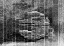
Side scan sonar image of 197-foot-diameter unidentified sunken object first discovered on June 19, 2011, 275 feet down on the floor of the Baltic Sea between Sweden and Finland. Side scan sonar image © 2011 by Ocean Explorer X-Team, Sweden.
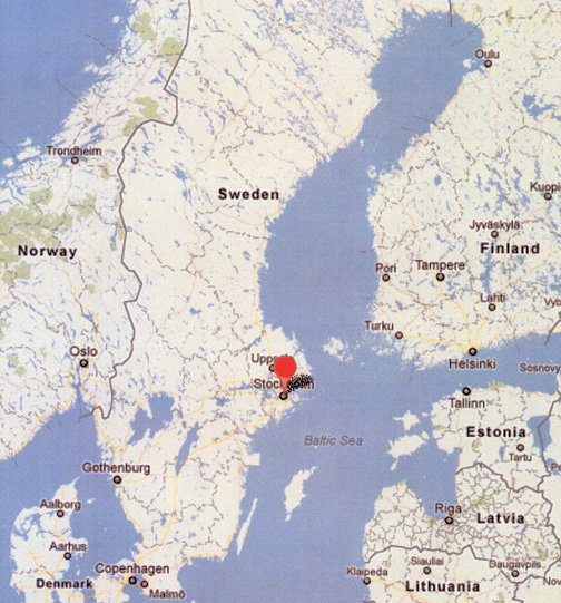
The red circle marks Stockholm, Sweden, facing the Baltic Sea, one of the largest brackish seas in the world. The water is a mixture of fresh and salt waters, but only about 35% as salty as the ocean. The Baltic waters are so murky that divers cannot see more than a few feet. The basin between Sweden and Finland was formed by glacial erosion. The Baltic Sea is about 1,600 kilometers (1,000 miles) long and averages 193 kilometers (120 miles) wide, with depths ranging from 55 meters (180 feet) to the maximum depth of 459 meters (1,506 feet).

August 28, 2012  Stockholm, Sweden - Today the Swedish EXPRESSEN.SE headlined the following update about the mysterious round object in the bottom of the Baltic Sea that has been investigated the past year by two long-time divers who joined together in the mid-1990s to hunt for sunken treasure in shipwrecks. Peter Lindberg and Dennis Asberg are co-owners of Sweden Ocean Explorer, a Stockholm company devoted to searching for sunken shipwrecks and treasure in the Baltic Sea, who call themselves the Ocean X Team.


Click here to subscribe and get instant access to read this report.

Click here to check your existing subscription status.

Existing members, login below:

Updated:  More Unexplained Boom Sounds from Sweden to Calif: What’s Happening Now in Sacramento?  And What Happened August 21st In Oakland, California?

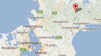
Lonsboda is in southern Sweden northeast of Copenhagen.

From:  Lonsboda, Sweden
Subject: Mysterious Boom Sounds

Date: August 26, 2012
To: [email protected]

"Hello!
I was reading your article on the mysterious explosion-like boom's that have occurred in the USA recently. I would like to report another one, but this time in the south of Sweden, near the town of Lönsboda. I would describe the sound as distant, if not underground.


Click here to subscribe and get instant access to read this report.

Click here to check your existing subscription status.

Existing members, login below: