Part 1:  High Strangeness in Dundee, Oregon

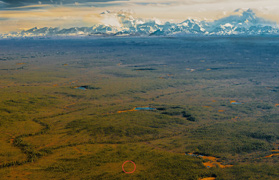
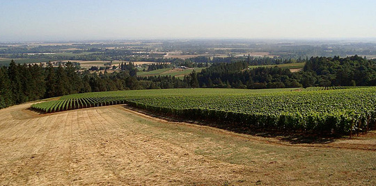
“I was repeatedly stalked by something at our vineyard property in Dundee, Oregon - something that would stand at the windows, leave palm
and nose prints, and scare the very sense out of my cats from a dead sleep.”

-Vincent Cantwell, Farmer, Dundee and Yamhill, Oregon

Dundee, Oregon, marked by the map marker, is about 12 miles northeast  of McMinnville and 27 miles southwest of Portland.
Dundee, Oregon, marked by the map marker, is about 12 miles northeast of McMinnville and 27 miles southwest of Portland.
Pinot Noir grapes in the Willamette Valley wine region of the Dundee Hills, Oregon. Image © 2008 by WineCountry.

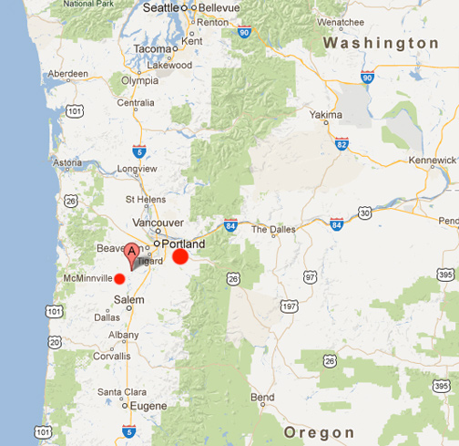
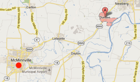
McMinnville, Oregon, is where on May 11, 1950, Mr. and Mrs. Paul Trent saw an aerial disc silently approach their house around 7:30 PM. The couple said the aerial object was very bright, almost silvery. Mrs. Trent ran indoors to get a camera to take to her husband, who took two photographs before the unidentified object moved away rapidly to the northwest. The photographs were studied by commercial photographers and by the Condon Committee at the University of Colorado. The consensus was that the Trent photographs were genuine.


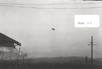
First of two disk photographs taken on May 11, 1950, at 7:30 PM by
Paul Trent in McMinnville, Oregon. Physicist Bruce Maccabee, commercial
photographers and the analyst for the Condon Committee at the University
of Colorado in 1966-1968, studied the negatives and prints and concluded
the photographs were genuine. Photograph © 1950 by Paul Trent.


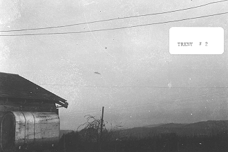
Second of two disk photographs taken on May 11, 1950,
by Paul Trent in McMinnville, Oregon. Photograph © 1950 by Paul Trent.


December 29, 2012  Dundee and Yamhill, Oregon - After the recent Earthfiles reports about November 28 to December 5, 2012, mysterious attacks on goats and bull calves in Waddy, Kentucky, and November to December 2012 sheep attacks in Worcester, England, I received the following email. [ See 122412 Earthfiles.


Click here to subscribe and get instant access to read this report.

Click here to check your existing subscription status.

Existing members, login below:

Updated: Nine Farm Animals Mysteriously Attacked in Waddy, Kentucky – By A Dog?

“All five of them were covered in blood and I started screaming. The skin had been ripped off their faces below their eyes and their tongues and ears were gone.”

- Teresa Parker, owner of 5 female goats attacked in Waddy, Kentucky


December 13, 2012, NBC-TV affiliate LEX18.com, Lexington, Kentucky. See Websites below.
December 13, 2012, The Sentinel-News, Shelbyville and Shelby County, Kentucky.
Waddy, Kentucky (red marker) is an unincorporated community within Shelby County 41 miles east of Louisville in north central Kentucky.

Updated December 24, 2012 / original report December 20, 2012  Waddy, Kentucky - Between the nights of November 28 and December 5, 2012, six goats and three calves were mysteriously attacked on Ditto Road in Waddy, Kentucky, 41 miles east of Louisville. The night of November 28 to 29, two 9-month-old bull calves on the Kevin Cox farm had their faces bloodied and their ears torn. Then on November 30th at 2 pm only about a mile from the Cox farm on Ditto Road, Teresa Parker discovered her five female goats with “their faces ripped off below their eyes, their tongues removed and their ears torn off.” All five goats were in their locked pen attached to a barn. Then on the night of December 3 - 4, the attacker returned to the Kevin Cox farm and attacked his daughter's goat. The ears “were ripped off and part of the face was bleeding.” Then on December 5, at the intersection of Ditto Road and Hickory Ridge Road another calf was attacked and bloodied. The owner requested anonymity.


Click here to subscribe and get instant access to read this report.

Click here to check your existing subscription status.

Existing members, login below:

Part 1:  Huge Aerial Triangle and Non-Human Entities in Army’s Fort Knox, KY.

"The triangle's random bottom lights were like camouflage
pretending to be the night sky. It was really weird because when
I realized it was a big triangle there in the air, it was almost like the
big triangular object was intelligent and became aware of my awareness.”

- J. S. Jones, Army Specialist, Fort Knox, Kentucky


J. S. Jones sketched this triangle-shaped aerial craft as he first saw it from his second story Fort Knox  Army barracks bedroom window in July 2003 after suddenly  being awakened. Illustration for Earthfiles © 2012 by J. S. Jones.
J. S. Jones sketched this triangle-shaped aerial craft as he first saw it from his second story Fort Knox Army barracks bedroom window in July 2003 after suddenly being awakened. Illustration for Earthfiles © 2012 by J. S. Jones.
Fort Knox, Kentucky (lower left red circle) is 35 miles southwest of Louisville. For seven decades, Fort Knox has been the U. S. Army's “Home of Cavalry and Armor.” Today at Fort Knox are the 3rd Brigade Combat Team, 1st Infantry Division;  Army Reserve Readiness Training Center; 100th Division Headquarters; the 3rd Sustainment Command (Expeditionary) and the Army's  Human Resource Center of Excellence.
Fort Knox, Kentucky (lower left red circle) is 35 miles southwest of Louisville. For seven decades, Fort Knox has been the U. S. Army's “Home of Cavalry and Armor.” Today at Fort Knox are the 3rd Brigade Combat Team, 1st Infantry Division; Army Reserve Readiness Training Center; 100th Division Headquarters; the 3rd Sustainment Command (Expeditionary) and the Army's Human Resource Center of Excellence.


December 11, 2012  Fort Knox, Kentucky - J. S. Jones (pseudonym at request) was born forty-five years ago in the Midwest. By 1985, J. S. had started college, but soon dropped out to enlist in the U. S. Army and began basic training at Fort Knox, Kentucky. Over the next twenty-three years, J. S. would be discharged and later re-enlist more than once in Army or Army National Guard service until his final U. S. Army discharge in early 2008.


Click here to subscribe and get instant access to read this report.

Click here to check your existing subscription status.

Existing members, login below:

What’s Causing Mysterious Lights, Loud Booms and Strange Hum in Narragansett Bay, Rhode Island?

- “The night of December 3, residents from Warwick, Rhode Island, to  Somerset, Massachusetts, heard a loud explosion with a bright light and a long sustained hum.”

- Don DePardo, Lieutenant, Johnston Fire Department, Johnston, Rhode Island

- “[October 25, 2012, disappearing radar blip] I just find it odd that Air Traffic Control would say, ‘We have a plane here missing. And then suddenly write it off as a flock of birds!  That just does not make sense to me.’”

- Don DePardo, Lt, Johnston Fire Department, Johnston, RI

- “ [October 17, 2012 Cranston, RI, big ‘bang’] not caused by F-15s ...  breaking the sound barrier is something we work hard not to do.”

- Maj. Matthew Mutti, Mass. Air National Guard


Click on map to enlarge. The red circles on the map show: Cranston, RI, region south of Providence and Johnston, October 17, 2012, at 5:10 p.m., loud “boom”;  then T.F. Green Airport about 6 miles north of Warwick where on October 25, 2012, at 7:30 AM, a plane radar blip disappeared; then Warwick northeast to Conimicut, RI, on December 3, 2012, first at 6:00 to 6:15 PM EST, a “dark sky blue disk with a black center” appeared; followed at 11:25 PM EST from Warwick and Conimicut to Barrington, Rhode Island, and Somerset, Massachusetts, hundreds of residents reported a very loud explosion-type sound followed by a strange hum for a long time afterward.

December  8, 2012   Warwick, Rhode Island - Unexplained lights, loud booms and strange humming sound have puzzled residents and authorities from Warwick and Providence, Rhode Island, to Somerset, Massachusetts region since October 17, through Monday, December 3, 2012.


Click here to subscribe and get instant access to read this report.

Click here to check your existing subscription status.

Existing members, login below:

Astronomer Carl Sagan’s Letter to U.K.’s MoD About Crop Circles

“Evidence has been uncovered showing some farmers have been paid considerable sums of money to destroy the real crop circles when they appear, and groups encouraged to then make hoaxed replicas.”

- From March 6, 1996, letter by astronomer Carl Sagan to U. K. Ministry of Defence


December 7, 2012   Albuquerque, New Mexico - On June 26, 1995, at Longwood Warren, Cheesefoot Head, near Winchester, Hampshire, England, a pattern was discovered in wheat that was described as a solar system. Cropcircleconnector.com reported, “Every circle and ring was flowing in a clockwise direction. Largest formation to appear in the area so far.” That summer, some half dozen “solar system” or “asteroid belt” patterns appeared, provoking questions by investigators about whether the patterns were warning that something might occur astronomically to Earth or in the solar system.


Click here to subscribe and get instant access to read this report.

Click here to check your existing subscription status.

Existing members, login below:

Part 2:  A Neurosurgeon’s “Proof of Heaven” – Evil Necessary in “Soul Schools”?

“When I was writing all this up, I could not use the word God because that was such a minimal concept in my previous mind compared to what I had seen - so I did use Om as my label because I remember hearing that in the deepest, darkest and brightest part of the Core - this awesome Om sound.”

- Eben Alexander, M. D., Neurosurgeon and Author, Proof of Heaven


Return to Part 1


December 2, 2012   Lynchburg, West Virginia - Part 2 continues with Dr. Alexander’s NDE realization that Earth is a “Soul School” where evil plays a role in the soul’s evolution and graduation to higher levels.


Click here to subscribe and get instant access to read this report.

Click here to check your existing subscription status.

Existing members, login below:

Update On Alleged Underground Alaskan “Dark Pyramid”

“Farewell Airport could have been a forward staging area to bring in equipment and supplies by helicopters to the ‘Square’ that you mentioned.”

- Airline Pilot and Retired USAF Lt. Col.

“The pilot told my dad the Alaska site was ‘every bit as hush hush
as the Manhattan Project.’ ...The pilot also told him that it was not a nuclear device; it was not made by man; nobody is supposed to know this place even exists. ...This thing is some kind of power generator and it’s thousands of years old, it’s made out of stone like a pyramid. They don’t know where it came from, who made it or how it works. But it can generate enough power to power the whole North Slope, all of Alaska, and probably the whole country of Canada!”

- Bruce L. Pearson, New Jersey

September 26, 2012, aerial of anomalous “green square” (red circle) with surrounding creeks that includes Highpower Creek and Mount McKinley to the southeast. Image © 2012 for Earthfiles by Frank Flavin.
September 26, 2012, aerial of anomalous “green square” (red circle) with surrounding creeks that includes Highpower Creek and Mount McKinley to the southeast.
Image © 2012 for Earthfiles by Frank Flavin.

November 30, 2012  Anchorage, Alaska - In my ongoing efforts to understand if the alleged underground and ancient “dark pyramid” in Alaska could be true, Earthfiles hired Alaskan aerial photographer Frank Flavin to fly in a helicopter on September 26, 2012, over the “green square” latitude/longitude discovered in Google Earth by a retired Navy Captain and described in earlier Earthfiles reports that include:


Click here to subscribe and get instant access to read this report.

Click here to check your existing subscription status.

Existing members, login below:

Part 1:  A Neurosurgeon’s “Proof of Heaven” – Angelic Beings and Human Families

“For me, it was very powerful to realize that both my adopted family and my birth family played tremendous roles in my understanding of that other realm and in that higher spiritual journey of our souls.”

- Eben Alexander, M. D., Surgeon, NDE Experiencer and Author, Proof of Heaven


November 30, 2012   Lynchburg, Virginia - Fifty-eight years ago, Eben Alexander was born in Charlotte, North Carolina - and then put up for adoption as a newly born infant. The family that adopted and named him encouraged his passions for learning and eventually for skydiving in college. Eben graduated from the University of North Carolina at Chapel Hill in 1976 with a major in chemistry. Then four years later in 1980, he graduated with an M. D. degree from Duke University Medical School. Afterward, he continued with a fellowship in cerebrovascular neurosurgery in the U. K.'s Newcastle-Upon-Tyne in northern England.


Click here to subscribe and get instant access to read this report.

Click here to check your existing subscription status.

Existing members, login below: