“There was no sign of blood anywhere and the horse
appeared to have just been deposited on the spot.”
- Manuel Leal, Houston Municipal Employee
“All of the animals (cats) have appeared to be mutilated in the same
calculated manner with what investigators believe to be an Exacto knife.”
- WINK-TV News, Southwest, Florida
December 3, 2011 Houston, Texas, and Port Charlotte, Florida - Earthfiles has received an email and photographs from Houston municipal employee, Manuel Leal, who discovered a freshly dead and mutilated horse lying in a ditch in the 5000 block of Schurmier Road south of downtown Houston on Friday, December 2, 2011. Mr. Leal also found another mutilated horse in the same ditch ten months ago on February 5, 2011.
Click here to subscribe and get instant access to read this report.
Click here to check your existing subscription status.
“Autopsy information obtained so far suggests that the occupants
mimic the features associated with Orientals ... autopsy notes mention a
rarely observed BLACKED OUT present which supports the premise
that these beings originate from another planet.”
- Page 0020126, “PART I PROJECT WHITE HOT
INTELLIGENCE ESTIMATE (PRELIMINARY)” from CIA to MAJIC, September 19, 1947
November 30, 2011 Albuquerque, New Mexico - Continuing from Part 7 with one of the longest documents leaked about “Examination of Unidentified Disc-like Aircraft” in New Mexico. This was a self-described “Preliminary” report dated September 19, 1947, MAJIC EYES ONLY, from the Central Intelligence Group in Washington, D. C., headed by U. S. Navy Rear Admiral Roscoe H. Hillenkoetter addressed to MAJIC: MILITARY ASSESSMENT OF THE JOINT INTELLIGENCE COMMITTEE.
Part 7 leads up to this Page 0020125: “PART I PROJECT WHITE HOT INTELLIGENCE ESTIMATE (PRELIMINARY).”
Click here to subscribe and get instant access to read this report.
Click here to check your existing subscription status.
“A large red-orange ball would come, it would rise in the air and split into five or six smaller orange orbs. This happened every two minutes for a half-hour!”
- Richard Vick, Insurance Agent, Kansas City, Missouri
November 23, 2011 Kansas City, Missouri - On June 14, 2011, independent insurance agent Richard Vick, 64, was driving home from a late meeting about 9:30 PM. Richard was traveling in the southbound lane of Missouri I-435 near Gregory Blvd., which is 71st Street. There was a dark, low, overcast sky and the night temperature was hot, about 90 degrees Fahrenheit.In the dark sky on his left, half a dozen orange-red small spheres appeared moving southeast towards Lee's Summit.
Click here to subscribe and get instant access to read this report.
Click here to check your existing subscription status.
“We modern humans, according to Hesiod, belong to the fifth race created by Zeus, the iron race, a mixture of ‘good and evil.’”
- Erich von Daniken, Author, Odyssey of the Gods:
The History of Extraterrestrial Contact in Ancient Greece
Zeus, the father of Gods and men, who ruled the Olympians on Mount Olympus, Greece, fought with Golden Age Titan giants and created and destroyed life.
November 23, 2011 Porter Ranch, California - For the past several months of 2011, I have been researching the possibility that the ancient Greek Zeus, Athena, Apollo, Prometheus and all the so-called “Greek Gods” were actually an extraterrestrial intelligence based on Earth - and not mythological constructs. This search began with a Homeland Security subcontractor's technical specialist who works with infrared cameras at an installation in Montgomery, Alabama. Four years ago right before sunrise on June 25, 2007, he was checking infrared cameras at his facility about six miles from Maxwell AFB and its Gunter AFB Annex in Montgomery, Alabama. Because his work is highly sensitive, he asked then - and now - that I not use his actual name. So I call him “Ted Connors.” That early morning, Ted encountered one of the "dragonfly" drones that were photographed by several people in 2007 - but the one he saw was right behind a tree on the Homeland Security subcontractor property, almost as if hiding. I reported about Ted's encounter back on June 25, 2007, for Earthfiles and Coast to Coast.
Click here to subscribe and get instant access to read this report.
Click here to check your existing subscription status.
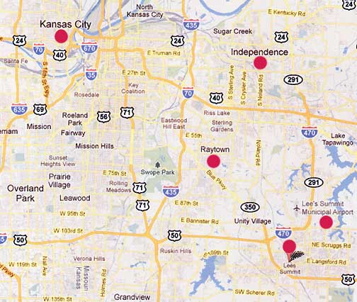
“The couple estimated the huge diamond craft was about 100 feet above their vehicle ... there was absolutely no sound.”
- Margie Kay, Asst. State Dir., Missouri MUFON
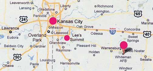
Since April 2011, Missouri MUFON has received dozens of reports about highly strange aerial phenomena ranging from morphing lights to beams to shapes ranging from diamond and triangular to oval and circular - all large and most silent. Primary geographic focuses of the phenomena have been Kansas City, Independence, Raytown and Lee's Summit.Whiteman AFB, home of the 509th Bomb Wing and B-2s, is southeast of Kansas City and Lee's Summit in Missouri. But B-2s and other terrestrial airplanes don't hover in the same place in the sky for several minutes silently morphing in shapes.
November 23, 2011 Independence, Missouri - On October 12, 2011, I first interviewed Margie Kay, Assistant State Director, Missouri Mutual UFO Network (MUFON), about the unidentified lights, spheres and other unusual aerial shapes reported by many citizens the previous week. See: 101211 Earthfiles.
Click here to subscribe and get instant access to read this report.
Click here to check your existing subscription status.
“Sunspot magnetic fields are dropping by about 50 gauss per year. If we extrapolate this trend into the future, sunspots could completely vanish around the year 2015.”
- Matt Penn, Ph.D., National Solar Observatory (NSO), Tucson, Arizona
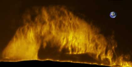
November 14, 2011 - Sun Prominence One of Biggest Ever Seen.
“I can't help but wonder what could possibly come next since we are still over a year away from the forecasted Solar Maximum (in mid-2013)?”
- Stephen Ramsden, Solar Photographer
Above: Biggest wall of plasma that many solar astronomers have ever seen photographed on November 11, 2011, by Stephen Ramsden, Atlanta. Earth superimposed for size comparison. Below: There is also a dark filament of magnetism stretching more than 621,371 miles (1 million km) around half the sun. Will it produce a Hyder flare? See: Spaceweather.com.
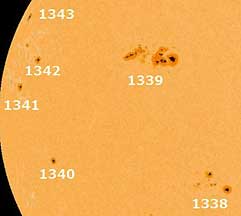
November 6, 2011 - Largest Sunspot Since 2005.
“It's still growing. The size is what blows me away.”
- Jess Whittington, Space Weather Prediction Center, Boulder, Colo.
The largest sunspots since 2005 are now visible from the Earth. 1339 (top center) is the largest of several sunspots that have been slowly rotating to face the Earth since November 3, 2011. Sunspot 1339 is 136,000 miles across. That's 17 times the Earth’s diameter of 8,000 miles. Sunspot 1339 erupted on November 3, with an intense X1.9 solar flare. Nov. 4 image by César Cantu, Monterrey, Mexico.
Sunspot 1339 has a Beta-Gamma Delta magnetic configuration and could produce further M-Class flares. Two new sunspots rotated into view Saturday on the eastern limb and were assigned the numbers 1341 and 1342. A third sunspot rotated into view Sunday morning and was numbered 1343. Sunspot 1338 recently released two small C-Flares.
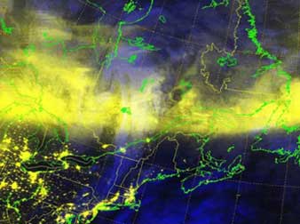
October 27, 2011 - Sun's Strong October 24th CME Provoked Auroras Over 33 States.
Earth's intense October 25, 2011, geomagnetic storm provoked by the sun's strong coronal mass ejection (CME) the day before created bright auroras in a band (yellow) that dropped down from Canada over the United States as far south as Louisiana. This image created by Paul McCrone at the Fleet Numerical Meteorology and Oceanography Center used October 25, 2011, 0140 GMT, visual and infrared data from the Defense Meteorological Satellite Program's F18 polar orbiter.
Spaceweather.com reports that “many observers, especially in the deep south, commented on the pure red color of the lights they saw. These rare all-red auroras sometimes appear at low latitudes during intense geomagnetic storms. They occur some 186 to 311 miles (300 to 500 km) above Earth's surface and are not yet fully understood.” See DMSP and Spaceweather.com.
October 24, 2011 - Intense Solar CME Today Compressed Earth's Magnetic Field.
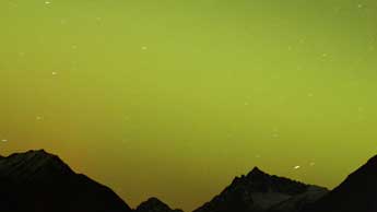
“The sky was brightly illuminated by auroras this evening in Norway.
The photo with yellow sky was taken at 19:20 UT right after the most extreme compression of the magnetosphere.”
Updated November 22 / Original October 30, 2011 Huntsville, Alabama - The third week of October 2011, solar physicists gathered in Sunspot, New Mexico, for the first in a series of three workshops to try to figure out what is happening in our sun. After nearly three years without sunspots leading into current Solar Cycle 24, physicists wonder if the sun is doing something differently, perhaps winding down into what is called a Grand Minimum where for decades the sun would not have sunspots.
Click here to subscribe and get instant access to read this report.
Click here to check your existing subscription status.
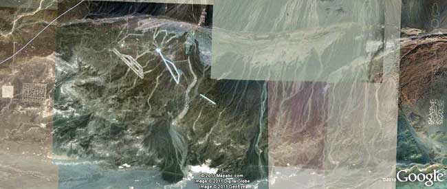
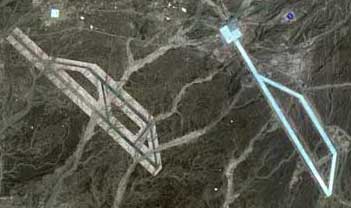
“The strange ‘grid’ pattern (far eastern edge of China ‘Area 51’ complex) in the images below was under construction on April 14, 2005, and looks complete one month later in the May 30, 2005, Google images.”
- Anton Zettl, Germany
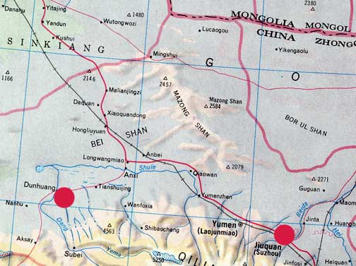
From left border to right border is about 20 miles in the China “Area 51” site near Dunhuang, Gansu Province, China. See maps below. The images in this Earthfiles report show that in July 2003, there was no construction. Then by 2005, construction had begun on one of the “runway” features and the far right “grid” above the Google logo.China's “Area 51” ground patterns are southwest of the Great Gobi Desert A in Gansu Province south of Mongolia (center red circle). The nearest town is Dunhuang (below) that is 1,515 miles (2,438 km) west of Beijing (far right red circle).Dunhuang (far left red circle), population 188,000, in Gansu Province southwest of the Great Gobi Desert A and Mongolia and about 200 miles west of China's Jiuquan Satellite Launch Center (JSLC), part of the Dongfeng Aerospace City (Base 10), far right red circle.
November 21, 2011 Albuquerque, New Mexico - Since posting my November 19, 2011, Earthfiles report “How Old Is China's ‘Area 51’?”, I have received important timeline information in the following emails from Anton Zettl of Germany, who have given me permission to use his research in this update. Following the timeline information is another important viewer contribution from Andrea Rich about the ancient Chinese “cracked ice” pattern seen in the two unusual “grid” patterns east and west (far right and left in top image above) about 20 miles apart at the “China Area 51” site.
Click here to subscribe and get instant access to read this report.
Click here to check your existing subscription status.
Update:November 20, 2011 - Bright, silver-white, morphing aerial object in Italian sky videotaped on November 7, 2011. Is it related to the Hoboken, New Jersey, and Mesa, Arizona, images?
November 7, 2011 Italian eyewitness report at UFO-sightings.net: “I was smoking a cigarette on the balcony of my house watching the sky...when i saw a strange object upon my house big as the moon. The object remained stationary for about one minute before starting to move. So I took my camera and start make the video... Live color was bright silver, but on camera the color is white. The object changed shape continuously, from edgy to smooth...seemed liquid. More witness saw the phenomena.” Italy case source: MUFON.
Click here to subscribe and get instant access to read this report.
Click here to check your existing subscription status.
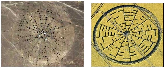
“The ‘Chinese desert disc’ - some people are comparing it to the Wilton Windmill 2010 crop picture, which shows a series of concentric rings, each coded in-to-out radially in 8-bit ASCII.”
- Horace Drew, Retired Geneticist, Sydney, Australia
“I am a retired engineer doing research with Google Earth. I analyzed image of the ‘Chinese Airport.’ The total outside perimeter of the left (west) airport is 22,360.6 feet, somewhat precisely the square root of 5.
The outer perimeter of the dark section is 22,360.6 / 16 / A where A= E -1 = 1.718281828, the fractal portion of natural log base E. I seriously doubt anybody in modern times would design anything like that.”
- J. D. Branson, World-Mysteries.com
Two “airstrips” described by retired engineer, J. D. Branson, as 22,360.6 feet long in the China “Area 51” large terraformed region that extends for 20 miles southwest of the Great Gobi Desert A near ancient Dunhuang and about 200 miles west of China's Jiuquan Satellite Launch Center. Image by Google Earth.
November 19, 2011 Dunhuang, Gansu Province, China - The first images called “China's Area 51” began circulating on the internet and in emails around November 7, 2011. Speculation was they might be geometric targets for satellite calibration. But others argue there are unusual mathematical relationships in the 20-mile wide terraformed complex. The location of the mysterious shapes are southwest of Great Gobi Desert A, Gansu Province, surrounded by a vast region of unpopulated land. Mongolia is to the north and the nearest town is Dunhuang, established in 111 B. C. as a frontier garrison outpost by the Han Dynasty Emperor Wudi. Today's population is 188,000.
Click here to subscribe and get instant access to read this report.
Click here to check your existing subscription status.
“I was home when the ‘quake’ hit. The first thing I noticed were TWO very loud noises which sounded like sonic booms ... then the house shook. I immediately went outside and heard military jets. Is the earthquake a cover-up for something else?”
- Grandin, Missouri resident, October 2011
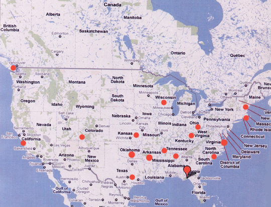
Red circles are locations where residents have heard “loud booms like a cannon” or “rolling, low thunder,” or “the first half of a lightening strike.” Recent unidentified, mysterious booms have been reported several times since December 2010 into November 2011, and the unexplained boom phenomenon goes back to reports in 1804.
Updated re: Yorktown, VA report November 13 / original report November 12, 2011 Yorktown, VA; Grandin, MO; Oklahoma City, OK -
1) Loud Boom in Yorktown, Virginia
“ ... shook the house last night (November 9) around 9 PM Eastern.”
Click here to subscribe and get instant access to read this report.
Click here to check your existing subscription status.