Updated – Part 1: Earthfiles Mail About High Strangeness

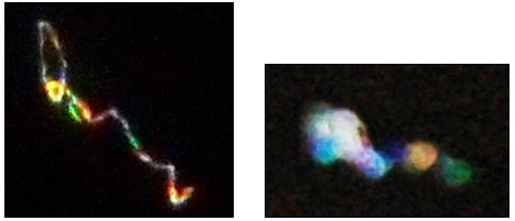
– “The colorful aerial lights in Norwood, Ontario, seem to be
in the same place every night and move through the sky much the same
as ‘regular’ stars…. almost like they masquerade as ‘normal’ stars.
It’s good to know we aren’t the only ones observing this.”

– Norwood, Ontario, Canada resident NE of Kitchener

Left:  November 13, 2011, 30-second exposure Image 015, Kodak Easyshare C142, © 2011 by Greg Crane, Kitchener, Ontario, Canada.  Right:  March 23, 2006, 1-second exposure Image 03, Nikon D70, © 2006 by J. D. Johnson, Lytle Creek, California,  east of Mount Baldy and northeast of San Bernardino.
Left: November 13, 2011, 30-second exposure Image 015, Kodak Easyshare C142, © 2011 by Greg Crane, Kitchener, Ontario, Canada. Right: March 23, 2006, 1-second exposure Image 03, Nikon D70, © 2006 by J. D. Johnson, Lytle Creek, California, east of Mount Baldy and northeast of San Bernardino.


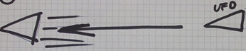
– “While there is conclusive evidence that large triangular craft
do transit our airspace, you can be equally sure they are not ours.”

– John B. Alexander, Ph.D., retired U. S. Army Colonel
and author © 2011 UFOs: Myths, Conspiracies and Realities

In 1993 to 1994, at 10 PM local time above an apartment building in Harjumaa, Estonia (Eastern Europe), three eyewitnesses were shocked by a rapidly low-flying, silent, 40-foot-long triangle-shaped craft.

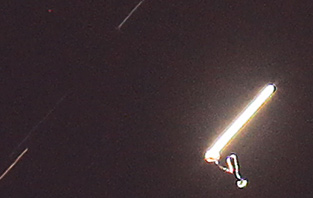
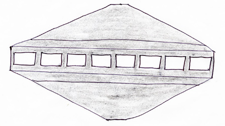
– “The saucer-shaped craft witnessed by Patrick Colligan
at RCC in Roswell is the same gigantic craft that I witnessed
in the summer of 1962 in Chicago, Illinois.”

– Naples, Florida resident

October 1, 2006, 11:15 PM Mountain, Roswell, New Mexico. Sketch of aerial craft with white glowing, rectangular windows that showed dull grey metal surface between each window. The estimated 650-foot-wide, completely silent craft moved slowly in the air over a cattle ranch behind the Roswell Correctional Center State Prison  about 25 miles south of Roswell. Correctional officer Pat Colligan made notes and sketch soon after his encounter with the huge craft.

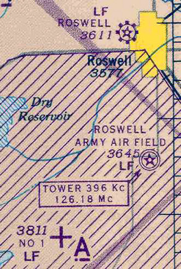
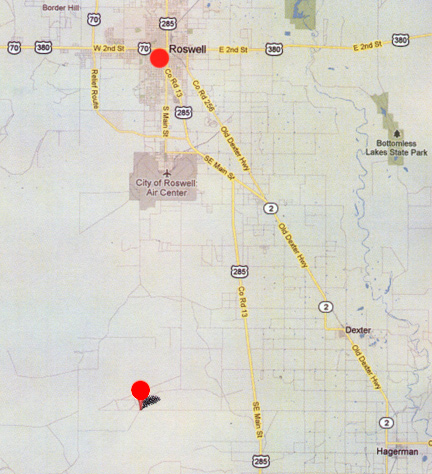
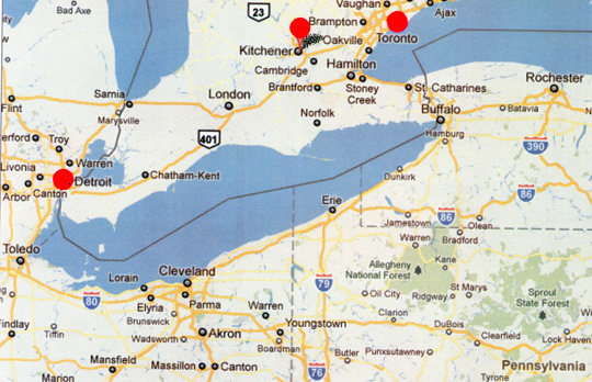
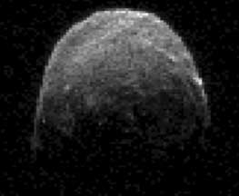
Updated – December 31, 2011  Albuquerque, New Mexico – Since my December 22 – 23, 2011, Earthfiles news reports and radio broadcast on Coast to Coast AM about the YU55 asteroid; unidentified multiple-colored aerial lights photographed over Kitchener, Ontario, Canada; and more information about UFO crashes near Roswell, New Mexico, in July 1947, and a dramatic close encounter with an enormous 650-foot-diameter aerial craft near the Roswell Correctional Center State Prison on October 1, 2006, I have received emails, illustrations and images from other eyewitnesses of similar phenomena.  An upcoming Part 2 includes an interview with the third listed eyewitness, J. D. Johnson, of Lake Elsinore, California, about his “plasma light” encounter that might involve missing time.Click for report.

Haunted Roswell: Huge, Cloaking Aerial Disc Encounter by NM State Prison Corrections Officer

“ All of a sudden to my left out the window, something very, very, very strange appeared - it's a giant flying saucer.

- Patrick Colligan, Corrections Officer, Roswell Correctional Center Prison

1944 aeronautical chart of Roswell, New Mexico (yellow) eight miles north of Roswell Army Air Field and its additional Auxiliary  No. 1 air field in lower left. Other auxiliary air fields were built south of Roswell. Historic map source Abandoned Airfields.
Red circle west of Dexter and Hagerman where another auxiliary air field with paved runways was built in the 1940s has been converted into the Roswell Correction Center (RCC), a New Mexico state prison.

December 23, 2011  Roswell, New Mexico - Patrick Colligan was born 53 years ago in Buffalo, New York. He graduated from Orchard Park High School in January 1976 and enlisted in the U. S. Air Force. Eventually in 1977, he graduated from the Nuclear Weapons Specialist School at Lowry AFB in Denver, Colorado. He had assignments from July 1977 to July 1980 in RAF Bentwaters/Woodbridge, England; then back to the United States at Strategic Air Command (SAC) stationed in Rome, New York at Griffiths AFB until January 1981.


Click here to subscribe and get instant access to read this report.

Click here to check your existing subscription status.

Existing members, login below:

Roswell 509th Bomb Wing Captain and “Non-Human Body Parts” in July 1947

“The RAAF security guard said he saw strange-looking metal in the crates in the off limits hangar ... and he had seen parts of bodies inside the hangar that did not look human.

- Patrick Murphy, 509th Bomber Wing Crew Chief, Pease AFB

Roswell Army Air Field (RAAF) sign in 1946.Walker Field was 8 miles south of Roswell. Photo source: USAF Historical Research Agency.
1944 aeronautical chart of Roswell, New Mexico (yellow) eight miles north of Roswell Army Air Field and its additional Auxiliary  No. 1 air field in lower left. Historic map source Chris Kennedy.

December 23, 2011  Springfield, Massachusetts - On  December 1st, I received an email from 57-year-old Patrick Amp L. Murphy, who served as an FB-111 Bomber Crew Chief and Inspector for the 509th Bomb Wing at Pease Air Force Base in New Hampshire after duty in Vietnam. Patrick worked with the 509th Bomb Wing from January 1973 to May 1975. His father, Francis R. Murphy, born in Springfield, Massachusetts in 1905, had enlisted in the U. S. Army in 1940. During World War II, he was promoted to Captain and was assigned to the 8th Army Air Corp with an intelligence unit on the front lines. He worked in North Africa desert wars and then was in Naples, Italy, until the war ended in 1945. Captain Murphy was wounded four times, received four purple hearts and a bronze star. From Italy, Capt. Murphy was assigned to Roswell Army Air Field, New Mexico, in late 1945 through 1947 to early 1948.


Click here to subscribe and get instant access to read this report.

Click here to check your existing subscription status.

Existing members, login below:

Part 3:  More Multi-Colored Aerial “Symbols”  Above Kitchener, Ontario, Canada. 

“ In the 30-second-exposure Image 038, the bright object is paralleling the star field and there is no camera stabilization explanation for the undulating trail that ends in a roundish object. Something moved from the bright object and was captured in that 30-second exposure.”

- Canon Camera Service Tech

Image 038: December 1, 2011, 6:48 PM Eastern, Kitchener, Ontario, Canada. Camera: Canon EOS 5D Mark II. Lens: Focal length 300 mm with 1.4 converter to 420 mm. Aperture 6.3. Shutter speed: 30-second time exposure. Image © 2011 by professional photographer Terry Scott White.
Toronto, Ontario, Canada (upper right red circle) is on Lake Ontario. Kitchener (middle red circle) is 57 miles (92 km) southwest of Toronto with a population of about 205,000, the fifth largest city in Ontario. Straight south is Lake Erie that also borders western New York and Pennsylvania, northern Ohio, and eastern Michigan (left red circle at Detroit).

Return to Part 1.

December 23, 2011  Kitchener, Ontario, Canada - Part 1 in this series of Earthfiles reports about high strangeness in the Kitchener, Ontario, Canada, sky summarized the similar multiple-colored patterns that people in many parts of the United States have taken since 2008, beginning with the UFO flap in Stephenville, Texas, in January 2008. Part 2 features series of images that Kitchener resident Greg Crane has photographed from the second week of September 2011 to mid-December 2011, including two 30-second exposures on November 13, 2011.


Click here to subscribe and get instant access to read this report.

Click here to check your existing subscription status.

Existing members, login below:

Updated: Asteroid YU55 “Puzzling Structures”:  Equatorial Ridge and Tall, “Pointy” Hill?

“There is a rather sharp, little pointy - hill?
It appears to be 66 feet to 98 feet (20 - 30 meters) above the
surrounding topography. We don't really understand yet what that is
- just one feature in particular that sticks up on YU55.”

- Lance Benner, Ph.D., Planetary Scientist and Asteroid Specialist,
NASA Jet Propulsion Lab, Pasadena, Calif.

Asteroid 2005 YU55 radar image of asteroid was obtained on November 7, 2011, at 11:45 AM PST when the space rock was at 3.6 lunar distances, about 860,000 miles (1.38 million km), from Earth. The next day November 8, at 3:28 PM Pacific, YU55 moved closest to the Earth at 30,000 mph, 201,700 miles from Earth measured from the center of our planet. Radar image credit: NASA/JPL-Caltech. See  NASA  Nov. 7 brief video of radar images in websites below.

Updated December 22, 2011: This week, I received the following email exchange from Russell, Kentucky resident Marty Dowell, who contacted her Congressman Ed Whitfield's office for more information about where the November 8, 9, and 10 radar images are from the close pass of the asteroid YU55 between Earth and moon. The Congressman's office received this emailed reply from NASA/JPL:   “NASA was unable to capture images of 2005 YU55 using radar on November 8 due to the rapid angle of motion of the object across the sky at that time.”


Click here to subscribe and get instant access to read this report.

Click here to check your existing subscription status.

Existing members, login below:

Part 9:  U. S. Government Knowledge of “Interplanetary” Craft, 1942 – 2011

“Flat panels of unknown metal have been suggested as a device associated with the operation ... It's mode of operation and purpose is unknown. ...Viewing may have been achieved by a form of television imagery. Symbolic notation appears to be the form of flight and control indicators.

- Page 0020128 Crash Retrieval Report
from CIA to MAJIC, September 19, 1947

Top:   Frame from 16mm B&W film of I-beam imprinted with early to classic Greek letters allegedly found in crash debris retrieved near Socorro, New Mexico, between May 31 to June 2, 1947, a month before the famous July 4 - 6, 1947, crashes around Roswell, New Mexico. Bottom:  Boston University Geologist Robert M. Schoch, Ph.D., photographed these four similar ancient Greek letters over an entrance at the Cheops great pyramid near Cairo in the 1990s. Image © by Robert M. Schoch, with permission.

Return to Part 1

Return to Part 8.

December 15, 2011  Albuquerque, New Mexico - Continuing from Part 8 with the leaked CIA to MAJIC September 19, 1947, “Project White Hot Intelligence Estimate (Preliminary)” report about the retrieval of three “unidentified lenticular-shaped aerodyne (ULAT)” craft from three different “Landing Zones” between July 4 and 6, 1947.


Click here to subscribe and get instant access to read this report.

Click here to check your existing subscription status.

Existing members, login below:

“God Particle” Search Narrows to 124 – 126 GeV.

“We have doubts. We are not yet sure. What we can tell you today is that we are sure that if the Higgs Boson is there, it will not escape
detection. It will definitely be discovered without any doubt in a year from now.”

- Guido Tonelli, Ph.D., Spokesperson, CERN CMS


A typical event illustrated above in CERN's Compact Muon Solenoid (CMS) search for the cosmic Standard Model Higgs Boson "God particle" in the Large Hadron Collider (LHC) data from 2010-2011. Two high-energy photons collide releasing energy depicted by dashed yellow lines and thicker red lines as measured in the CMS electromagnetic calorimeter. The yellow lines are the measured tracks of other particles produced in the collision. Graphic source: CERN.

December  13, 2011 Geneva, Switzerland - The Large Hadron Collider at the European Laboratory for Particle Physics known as CERN collides hadrons together to see what the matter part of the universe is made of down to the smallest subatomic particles. Hadrons are subatomic particles made of quarks held together by the strong force, while atoms and molecules are held together by the electromagnetic force. The best known hadrons are protons and neutrons that make up the nucleus in each atom. Theoretically in the physics “Standard Model”  of how the universe is constructed, protons have mass because of a theoretical subatomic particle called a Higgs Boson.


Click here to subscribe and get instant access to read this report.

Click here to check your existing subscription status.

Existing members, login below:

Part 2:  More Multi-Colored Aerial “Symbols”- This Time Above Kitchener, Ontario, Canada

“My gut feeling is that I do think these strange, colorful objects are alien.”

- Greg Crane, Resident, Kitchener, Ontario, Canada


Return to Part 1.


December  12, 2011  Kitchener, Ontario, Canada - Greg Crane has lived most of his 44 years in Kitchener, Ontario, Canada. Greg has also loved working on machines since dropping out of high school to restore an old car. He now is a professional restorer of antique cars and works out of the same home and office he's had for eighteen years. So, Greg is very familiar with the landscape and sky around his place that was built on the side of a hill. The hilltop rises to the east blocking out that part of the sky. But Greg has clear views of the west, south and north.

Toronto, Ontario, Canada (upper right red circle) is on Lake Ontario. Kitchener (middle red circle) is 57 miles (92 km) southwest of Toronto with a population of about 205,000, the fifth largest city in Ontario. Straight south is Lake Erie that also borders western New York and Pennsylvania, northern Ohio, and eastern Michigan (left red circle at Detroit).


Click here to subscribe and get instant access to read this report.

Click here to check your existing subscription status.

Existing members, login below:

Medical Descriptions of Artificial Androids Not from Earth

“The ‘skin’ was nothing like anything I’d seen before. It was just like a fabric suit (leotard), but the suit was its flesh at the same time.’ ”

- USAF Flight Surgeon, Wright-Patterson AFB, Ohio, circa 1947


December  9, 2011 Wright-Patterson AFB, Dayton, Ohio - On April 24, 2006, I received an email from a Central Ohio businessman named Ronald SeCoy. He is 59-years-old, has a Bachelor's degree in Clinical Psychology from Ohio University, but has worked in a variety of businesses ranging from restaurants to retail since graduating. He is a family man with three children and considers himself a devout Christian. He has asked that his home city and company's name be withheld for protection. His first email stated:


Click here to subscribe and get instant access to read this report.

Click here to check your existing subscription status.

Existing members, login below:

Earthfiles