Updated Part 2: Chualar Barley Pattern’s Mysterious Braille 192 and Morse Code

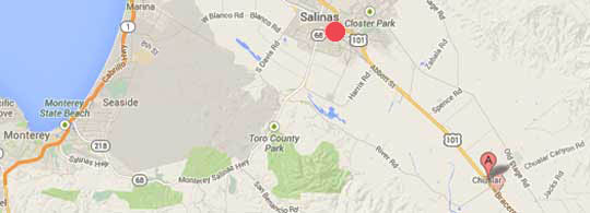
Chualar (CHOO-ah-lahr), California, is 11 miles southeast of Salinas. Chualar Canyon Road  runs southwest to northeast through Chualar. The barley pattern was oriented southeast  to northwest in the field with a telephone pole at the southern center of the pattern.
Chualar (CHOO-ah-lahr), California, is 11 miles southeast of Salinas. Chualar Canyon Road runs southwest to northeast through Chualar. The barley pattern was oriented southeast to northwest in the field with a telephone pole at the southern center of the pattern.
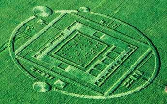
36 degrees 35' 03" N 121 degrees 28'23" W 250 feet in diameter.  Retired Navy Captain Mark Wood has analyzed Google Earth images of the Chualar, California, field and concludes the diameter  of the December 28, 2013, pattern in the 2 to 3 foot barley is 250 feet.  The difficulty in estimates by people on the ground is that the  land within the large rectangular frame sinks down like a shallow bowl. From the telephone pole on the south (far right above aerial),  only the southern parts of the pattern could be seen.  Aerial © by 111th Aerial Photography & Video.
36 degrees 35' 03" N 121 degrees 28'23" W 250 feet in diameter.

Retired Navy Captain Mark Wood has analyzed Google Earth images of the Chualar, California, field and concludes the diameter of the December 28, 2013, pattern in the 2 to 3 foot barley is 250 feet. The difficulty in estimates by people on the ground is that the land within the large rectangular frame sinks down like a shallow bowl. From the telephone pole on the south (far right above aerial), only the southern parts of the pattern could be seen. Aerial © by 111th Aerial Photography & Video.


Click here to subscribe and get instant access to read this report.

Click here to check your existing subscription status.

Existing members, login below:


© 1998 - 2024 by Linda Moulton Howe.
All Rights Reserved.